Richha geodata
Richha (Uttar Pradesh) is a populated place; located in India in Asia/Kolkata (GMT+5.5) time zone. With population of 19,459 people, there are 2078 cities with bigger population in this country. Compared to other cities in India, 87.8% of cities are located further ↓South; 64% of cities are located further ←West and 52.5% of cities have higher elevation than Richha. Note1


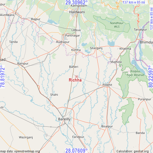
Richha GPS coordinates[2]
28° 41' 40.812" North, 79° 31' 22.224" East
| Map corner | latitude | longitude |
|---|---|---|
| Upper-left | 29.30962°, | 78.81972° |
| Center: | 28.69467°, | 79.52284° |
| Lower-right: | 28.07609°, | 80.22597° |
| Map W x H: | 137.2×137.2 km | = 85.3×85.3mi |
| max Lat: | 34.9274° ⇑12.2% North |
| Richha: | 28.69467° |
| min Lat: | ⇓87.8% South 8.09008° |
| min Long | Richha | max Long |
| 68.82655° | 79.52284° | 96.81° |
| W 64%⇐ | ⇒36% E |
Elevation
Elevation of Richha is 187 m = 614 ft, and this is 108.6 m = 356 ft below average elevation for this country.
| Max E: |
3681 m = 12077 ft | 52.5% |
| Avg. | 295.6 m = 970 ft | |
| Richha | 187 m = 614 ft | |
Min E: |
1 m = 3 ft | 47.5% |
See also: India elevation on elevation.city.
Geographical zone
Richha is located in North temperate zone (between Tropic of Cancer and the Arctic Circle). Distance of this Northern Tropic circle is 584.6 km =363.3 mi to South.| Distance of | km | miles | from Richha |
|---|---|---|---|
| North Pole | 6816.5 | 4235.6 | to North |
| Arctic Circle | 4210.6 | 2616.3 | to North |
| Tropic Cancer | 584.6 | 363.3 | to South |
| Equator | 3190.5 | 1982.5 | to South |


Nearby cities:
15 places around Richha: (largest is in red/bold)
• Baheri
9.2 km =5.7 mi,  344°
344°
• Bīlāspur
32.6 km =20.3 mi,  310°
310°
• Deoraniān
8.5 km =5.3 mi,  212°
212°
• Fatehganj West
33 km =20.5 mi,  219°
219°
• Jahānābād
20.4 km =12.7 mi,  110°
110°
• Kemrī
33.4 km =20.8 mi,  291°
291°
• Kichha
24.1 km =15 mi,  359°
359°
• Milak
35.7 km =22.2 mi,  254°
254°
• Mīrganj
35.2 km =21.9 mi,  240°
240°
• Nawābganj
20.3 km =12.6 mi,  147°
147°
• Pīlibhīt
28.4 km =17.6 mi,  104°
104°
• Shergarh
15.8 km =9.8 mi, 252°
• Shāhi
25.7 km =16 mi,  231°
231°
• Shīshgarh
20.7 km =12.9 mi,  280°
280°
• Sitārganj
31.5 km =19.6 mi,  34°
34°
Sources, notices
• [Note1] Compared only with cities in India existing in our database
• [Src1] Map data: © OpenStreetMap contributors (CC-BY-SA)
• [Src2] Other city data from geonames.org with taken over terms of usage.
• [Src3] Geographical zone / Annual Mean Temperature by Robert A. Rohde @ Wikipedia
