Bareilly geodata
Bareilly (Uttar Pradesh) is a populated place; located in India in Asia/Kolkata (GMT+5.5) time zone. With population of 745,435 people, there are 63 cities with bigger population in this country. Compared to other cities in India, 86.2% of cities are located further ↓South; 63% of cities are located further ←West and 54.4% of cities have higher elevation than Bareilly. Note1


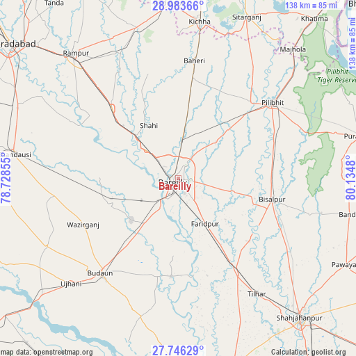
Bareilly GPS coordinates[2]
28° 22' 0.408" North, 79° 25' 54.012" East
| Map corner | latitude | longitude |
|---|---|---|
| Upper-left | 28.98366°, | 78.72855° |
| Center: | 28.36678°, | 79.43167° |
| Lower-right: | 27.74629°, | 80.1348° |
| Map W x H: | 137.6×137.6 km | = 85.5×85.5mi |
| max Lat: | 34.9274° ⇑13.8% North |
| Bareilly: | 28.36678° |
| min Lat: | ⇓86.2% South 8.09008° |
| min Long | Bareilly | max Long |
| 68.82655° | 79.43167° | 96.81° |
| W 63%⇐ | ⇒37% E |
Elevation
Elevation of Bareilly is 178 m = 584 ft, and this is 117.6 m = 386 ft below average elevation for this country.
| Max E: |
3681 m = 12077 ft | 54.4% |
| Avg. | 295.6 m = 970 ft | |
| Bareilly | 178 m = 584 ft | |
Min E: |
1 m = 3 ft | 45.6% |
See also: Bareilly elevation on elevation.city.
Geographical zone
Bareilly is located in North temperate zone (between Tropic of Cancer and the Arctic Circle). Distance of this Northern Tropic circle is 548.2 km =340.6 mi to South.| Distance of | km | miles | from Bareilly |
|---|---|---|---|
| North Pole | 6853 | 4258.3 | to North |
| Arctic Circle | 4247.1 | 2639 | to North |
| Tropic Cancer | 548.2 | 340.6 | to South |
| Equator | 3154.1 | 1959.9 | to South |


Nearby cities:
15 places around Bareilly: (largest is in red/bold)
• Aonla
28 km =17.4 mi,  248°
248°
• Barkhera Kalān
37.9 km =23.5 mi,  75°
75°
• Bīsalpur
37.4 km =23.2 mi,  102°
102°
• Deoraniān
29.6 km =18.4 mi,  8°
8°
• Dātāganj
38 km =23.6 mi,  183°
183°
• Farīdpur
20.5 km =12.7 mi,  148°
148°
• Fatehganj West
16.5 km =10.3 mi,  312°
312°
• Khudāganj
37 km =23 mi,  131°
131°
• Milak
37.2 km =23.1 mi,  316°
316°
• Mīrganj
29.1 km =18.1 mi, 311°
• Nawābganj
27.7 km =17.2 mi,  45°
45°
• Richha
37.5 km =23.3 mi, 13°
• Sarauli
36.1 km =22.4 mi,  293°
293°
• Shergarh
32.2 km =20 mi,  348°
348°
• Shāhi
23.2 km =14.4 mi,  331°
331°
Sources, notices
• [Note1] Compared only with cities in India existing in our database
• [Src1] Map data: © OpenStreetMap contributors (CC-BY-SA)
• [Src2] Other city data from geonames.org with taken over terms of usage.
• [Src3] Geographical zone / Annual Mean Temperature by Robert A. Rohde @ Wikipedia
