Nawābganj geodata
Nawābganj (Uttar Pradesh) is a populated place; located in India in Asia/Kolkata (GMT+5.5) time zone. With population of 34,134 people, there are 1274 cities with bigger population in this country. Compared to other cities in India, 86.9% of cities are located further ↓South; 65% of cities are located further ←West and 53% of cities have higher elevation than Nawābganj. Note1


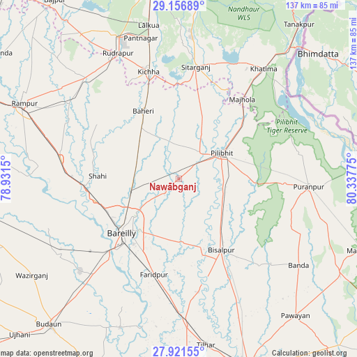
Nawābganj GPS coordinates[2]
28° 32' 27.708" North, 79° 38' 4.632" East
| Map corner | latitude | longitude |
|---|---|---|
| Upper-left | 29.15689°, | 78.9315° |
| Center: | 28.54103°, | 79.63462° |
| Lower-right: | 27.92155°, | 80.33775° |
| Map W x H: | 137.4×137.4 km | = 85.4×85.4mi |
| max Lat: | 34.9274° ⇑13.1% North |
| Nawābganj: | 28.54103° |
| min Lat: | ⇓86.9% South 8.09008° |
| min Long | Nawābganj | max Long |
| 68.82655° | 79.63462° | 96.81° |
| W 65%⇐ | ⇒35% E |
Elevation
Elevation of Nawābganj is 184 m = 604 ft, and this is 111.6 m = 366 ft below average elevation for this country.
| Max E: |
3681 m = 12077 ft | 53% |
| Avg. | 295.6 m = 970 ft | |
| Nawābganj | 184 m = 604 ft | |
Min E: |
1 m = 3 ft | 47% |
See also: India elevation on elevation.city.
Geographical zone
Nawābganj is located in North temperate zone (between Tropic of Cancer and the Arctic Circle). Distance of this Northern Tropic circle is 567.5 km =352.6 mi to South.| Distance of | km | miles | from Nawābganj |
|---|---|---|---|
| North Pole | 6833.6 | 4246.2 | to North |
| Arctic Circle | 4227.7 | 2627 | to North |
| Tropic Cancer | 567.5 | 352.6 | to South |
| Equator | 3173.5 | 1971.9 | to South |


Nearby cities:
15 places around Nawābganj: (largest is in red/bold)
• Baheri
29.2 km =18.1 mi,  332°
332°
• Bareilly
27.7 km =17.2 mi,  225°
225°
• Barkhera Kalān
19.5 km =12.1 mi,  120°
120°
• Bīsalpur
32.3 km =20.1 mi,  148°
148°
• Deoraniān
18.3 km =11.4 mi,  302°
302°
• Farīdpur
37.9 km =23.5 mi,  193°
193°
• Fatehganj West
33.1 km =20.6 mi,  255°
255°
• Jahānābād
12.8 km =8 mi,  39°
39°
• Kichha
42.7 km =26.5 mi,  344°
344°
• Mīrganj
41.7 km =25.9 mi,  269°
269°
• Pīlibhīt
19.4 km =12.1 mi,  58°
58°
• Richha
20.3 km =12.6 mi, 327°
• Shergarh
28.8 km =17.9 mi, 295°
• Shāhi
31 km =19.3 mi, 271°
• Shīshgarh
37.6 km =23.4 mi, 303°
Sources, notices
• [Note1] Compared only with cities in India existing in our database
• [Src1] Map data: © OpenStreetMap contributors (CC-BY-SA)
• [Src2] Other city data from geonames.org with taken over terms of usage.
• [Src3] Geographical zone / Annual Mean Temperature by Robert A. Rohde @ Wikipedia
