Bīlāspur geodata
Bīlāspur (Uttar Pradesh) is a populated place; located in India in Asia/Kolkata (GMT+5.5) time zone. With population of 39,873 people, there are 1111 cities with bigger population in this country. Compared to other cities in India, 88.7% of cities are located further ↓South; 61.5% of cities are located further ←West and 50.5% of cities have higher elevation than Bīlāspur. Note1


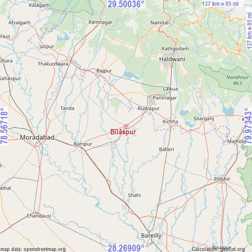
Bīlāspur GPS coordinates[2]
28° 53' 11.58" North, 79° 16' 13.08" East
| Map corner | latitude | longitude |
|---|---|---|
| Upper-left | 29.50036°, | 78.56718° |
| Center: | 28.88655°, | 79.2703° |
| Lower-right: | 28.26909°, | 79.97343° |
| Map W x H: | 136.9×136.9 km | = 85.1×85.1mi |
| max Lat: | 34.9274° ⇑11.3% North |
| Bīlāspur: | 28.88655° |
| min Lat: | ⇓88.7% South 8.09008° |
| min Long | Bīlāspur | max Long |
| 68.82655° | 79.2703° | 96.81° |
| W 61.5%⇐ | ⇒38.5% E |
Elevation
Elevation of Bīlāspur is 199 m = 653 ft, and this is 96.6 m = 317 ft below average elevation for this country.
| Max E: |
3681 m = 12077 ft | 50.5% |
| Avg. | 295.6 m = 970 ft | |
| Bīlāspur | 199 m = 653 ft | |
Min E: |
1 m = 3 ft | 49.5% |
See also: India elevation on elevation.city.
Geographical zone
Bīlāspur is located in North temperate zone (between Tropic of Cancer and the Arctic Circle). Distance of this Northern Tropic circle is 606 km =376.6 mi to South.| Distance of | km | miles | from Bīlāspur |
|---|---|---|---|
| North Pole | 6795.2 | 4222.3 | to North |
| Arctic Circle | 4189.3 | 2603.1 | to North |
| Tropic Cancer | 606 | 376.6 | to South |
| Equator | 3211.9 | 1995.8 | to South |


Nearby cities:
15 places around Bīlāspur: (largest is in red/bold)
• Baheri
25.4 km =15.8 mi,  119°
119°
• Bāzpur
33.6 km =20.9 mi,  331°
331°
• Deoraniān
34.9 km =21.7 mi,  144°
144°
• Kemrī
10.9 km =6.8 mi,  215°
215°
• Kichha
24.5 km =15.2 mi,  83°
83°
• Milak
32.2 km =20 mi,  197°
197°
• Mīrganj
39 km =24.2 mi,  188°
188°
• Richha
32.6 km =20.3 mi,  130°
130°
• Rāmpur
25.2 km =15.7 mi,  250°
250°
• Shergarh
27.8 km =17.3 mi,  159°
159°
• Shāhi
37.7 km =23.4 mi,  172°
172°
• Shīshgarh
18 km =11.2 mi, 166°
• Sitārganj
42.5 km =26.4 mi, 83°
• Suār
26.1 km =16.2 mi,  307°
307°
• Tānda
33.5 km =20.8 mi,  287°
287°
Sources, notices
• [Note1] Compared only with cities in India existing in our database
• [Src1] Map data: © OpenStreetMap contributors (CC-BY-SA)
• [Src2] Other city data from geonames.org with taken over terms of usage.
• [Src3] Geographical zone / Annual Mean Temperature by Robert A. Rohde @ Wikipedia
