Sendhwa geodata
Sendhwa (Madhya Pradesh) is a populated place; located in India in Asia/Kolkata (GMT+5.5) time zone. With population of 54,530 people, there are 815 cities with bigger population in this country. Compared to other cities in India, 58.1% of cities are located further ↑North; 82% of cities are located further →East and 76.7% of cities have lower elevation than Sendhwa. Note1


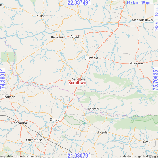
Sendhwa GPS coordinates[2]
21° 41' 8.232" North, 75° 5' 46.392" East
| Map corner | latitude | longitude |
|---|---|---|
| Upper-left | 22.33749°, | 74.3931° |
| Center: | 21.68562°, | 75.09622° |
| Lower-right: | 21.03079°, | 75.79935° |
| Map W x H: | 145.3×145.3 km | = 90.3×90.3mi |
| max Lat: | 34.9274° ⇑58.1% North |
| Sendhwa: | 21.68562° |
| min Lat: | ⇓41.9% South 8.09008° |
| min Long | Sendhwa | max Long |
| 68.82655° | 75.09622° | 96.81° |
| W 18%⇐ | ⇒82% E |
Elevation
Elevation of Sendhwa is 410 m = 1345 ft, and this is 114.4 m = 375 ft above average elevation for this country.
| Max E: |
3681 m = 12077 ft | 23.3% |
| Sendhwa | 410 m 1345 ft | |
| Avg. | 295.6 m = 970 ft | |
Min E: |
1 m = 3 ft | 76.7% |
See also: Sendhwa elevation on elevation.city.
Geographical zone
Sendhwa is located in North Torrid zone (between Equator and Tropic of Cancer). Distance of this Northern Tropic circle is 194.7 km =121 mi to North.| Distance of | km | miles | from Sendhwa |
|---|---|---|---|
| North Pole | 7595.8 | 4719.8 | to North |
| Arctic Circle | 4990 | 3100.6 | to North |
| Tropic Cancer | 194.7 | 121 | to North |
| Equator | 2411.2 | 1498.2 | to South |


Nearby cities:
15 places around Sendhwa: (largest is in red/bold)
• Amalner
71.9 km =44.7 mi,  183°
183°
• Anjad
39.8 km =24.7 mi,  353°
353°
• Barwāni
43.6 km =27.1 mi,  332°
332°
• Chopda
53.2 km =33.1 mi,  156°
156°
• Dharampuri
57.6 km =35.8 mi,  26°
26°
• Dhāmnod
69.9 km =43.4 mi, 33°
• Dondaicha
67.9 km =42.2 mi,  233°
233°
• Khargone
55.6 km =34.5 mi,  74°
74°
• Khetia
52.8 km =32.8 mi,  268°
268°
• Kukshi
67.6 km =42 mi, 328°
• Manāwar
61.2 km =38 mi,  359°
359°
• Pānsemāl
41.1 km =25.5 mi, 265°
• Rajpur
28.6 km =17.8 mi,  8°
8°
• Shirpur
43.7 km =27.2 mi,  210°
210°
• Shāhāda
66.5 km =41.3 mi,  256°
256°
Sources, notices
• [Note1] Compared only with cities in India existing in our database
• [Src1] Map data: © OpenStreetMap contributors (CC-BY-SA)
• [Src2] Other city data from geonames.org with taken over terms of usage.
• [Src3] Geographical zone / Annual Mean Temperature by Robert A. Rohde @ Wikipedia
