Barwāni geodata
Barwāni (Madhya Pradesh) is a populated place; located in India in Asia/Kolkata (GMT+5.5) time zone. With population of 47,343 people, there are 933 cities with bigger population in this country. Compared to other cities in India, 56.5% of cities are located further ↑North; 83.5% of cities are located further →East and 53.5% of cities have higher elevation than Barwāni. Note1


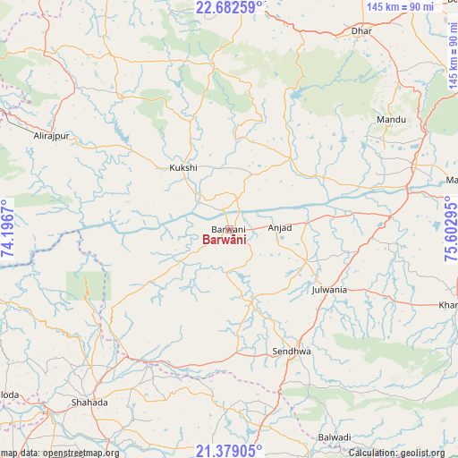
Barwāni GPS coordinates[2]
22° 1' 56.352" North, 74° 53' 59.352" East
| Map corner | latitude | longitude |
|---|---|---|
| Upper-left | 22.68259°, | 74.1967° |
| Center: | 22.03232°, | 74.89982° |
| Lower-right: | 21.37905°, | 75.60295° |
| Map W x H: | 144.9×144.9 km | = 90×90mi |
| max Lat: | 34.9274° ⇑56.5% North |
| Barwāni: | 22.03232° |
| min Lat: | ⇓43.5% South 8.09008° |
| min Long | Barwāni | max Long |
| 68.82655° | 74.89982° | 96.81° |
| W 16.5%⇐ | ⇒83.5% E |
Elevation
Elevation of Barwāni is 182 m = 597 ft, and this is 113.6 m = 373 ft below average elevation for this country.
| Max E: |
3681 m = 12077 ft | 53.5% |
| Avg. | 295.6 m = 970 ft | |
| Barwāni | 182 m = 597 ft | |
Min E: |
1 m = 3 ft | 46.5% |
See also: Barwāni elevation on elevation.city.
Geographical zone
Barwāni is located in North Torrid zone (between Equator and Tropic of Cancer). Distance of this Northern Tropic circle is 156.2 km =97.1 mi to North.| Distance of | km | miles | from Barwāni |
|---|---|---|---|
| North Pole | 7557.3 | 4695.9 | to North |
| Arctic Circle | 4951.4 | 3076.7 | to North |
| Tropic Cancer | 156.2 | 97.1 | to North |
| Equator | 2449.8 | 1522.2 | to South |


Nearby cities:
15 places around Barwāni: (largest is in red/bold)
• Anjad
16 km =9.9 mi,  86°
86°
• Bāg
38 km =23.6 mi,  342°
342°
• Dharampuri
47.6 km =29.6 mi,  74°
74°
• Dhāmnod
62 km =38.5 mi, 71°
• Jobat
54.6 km =33.9 mi,  321°
321°
• Khetia
51.6 km =32.1 mi,  218°
218°
• Kukshi
24.3 km =15.1 mi, 322°
• Maheshwar
72.6 km =45.1 mi,  77°
77°
• Manāwar
29.9 km =18.6 mi,  40°
40°
• Pānsemāl
46.3 km =28.8 mi,  206°
206°
• Rajpur
26.4 km =16.4 mi,  112°
112°
• Rajpur
63.7 km =39.6 mi,  298°
298°
• Rājgarh
72 km =44.7 mi,  3°
3°
• Sendhwa
43.6 km =27.1 mi,  152°
152°
• Shāhāda
69.9 km =43.4 mi, 219°
Sources, notices
• [Note1] Compared only with cities in India existing in our database
• [Src1] Map data: © OpenStreetMap contributors (CC-BY-SA)
• [Src2] Other city data from geonames.org with taken over terms of usage.
• [Src3] Geographical zone / Annual Mean Temperature by Robert A. Rohde @ Wikipedia
