Amalner geodata
Amalner (Maharashtra) is a populated place; located in India in Asia/Kolkata (GMT+5.5) time zone. With population of 97,369 people, there are 454 cities with bigger population in this country. Compared to other cities in India, 61.5% of cities are located further ↑North; 82.3% of cities are located further →East and 52.2% of cities have higher elevation than Amalner. Note1


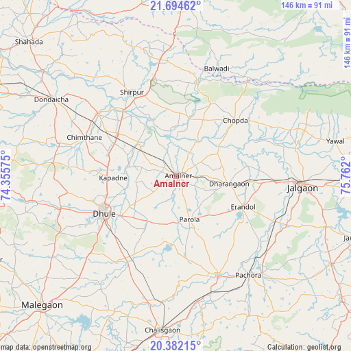
Amalner GPS coordinates[2]
21° 2' 23.388" North, 75° 3' 31.932" East
| Map corner | latitude | longitude |
|---|---|---|
| Upper-left | 21.69462°, | 74.35575° |
| Center: | 21.03983°, | 75.05887° |
| Lower-right: | 20.38215°, | 75.762° |
| Map W x H: | 145.9×145.9 km | = 90.7×90.7mi |
| max Lat: | 34.9274° ⇑61.5% North |
| Amalner: | 21.03983° |
| min Lat: | ⇓38.5% South 8.09008° |
| min Long | Amalner | max Long |
| 68.82655° | 75.05887° | 96.81° |
| W 17.7%⇐ | ⇒82.3% E |
Elevation
Elevation of Amalner is 189 m = 620 ft, and this is 106.6 m = 350 ft below average elevation for this country.
| Max E: |
3681 m = 12077 ft | 52.2% |
| Avg. | 295.6 m = 970 ft | |
| Amalner | 189 m = 620 ft | |
Min E: |
1 m = 3 ft | 47.8% |
See also: Amalner elevation on elevation.city.
Geographical zone
Amalner is located in North Torrid zone (between Equator and Tropic of Cancer). Distance of this Northern Tropic circle is 266.5 km =165.6 mi to North.| Distance of | km | miles | from Amalner |
|---|---|---|---|
| North Pole | 7667.7 | 4764.5 | to North |
| Arctic Circle | 5061.8 | 3145.3 | to North |
| Tropic Cancer | 266.5 | 165.6 | to North |
| Equator | 2339.4 | 1453.6 | to South |


Nearby cities:
15 places around Amalner: (largest is in red/bold)
• Bhusāval
75.4 km =46.9 mi,  89°
89°
• Chopda
33.9 km =21.1 mi,  47°
47°
• Chālisgaon
64.9 km =40.3 mi,  183°
183°
• Dharangaon
22.6 km =14 mi,  97°
97°
• Dhūlia
33 km =20.5 mi,  242°
242°
• Dondaicha
59.9 km =37.2 mi,  301°
301°
• Erandol
30.7 km =19.1 mi,  115°
115°
• Jalgaon
52.8 km =32.8 mi, 94°
• Mālegaon
77.1 km =47.9 mi,  224°
224°
• Parola
18.7 km =11.6 mi,  160°
160°
• Pāchora
51.5 km =32 mi,  143°
143°
• Sendhwa
71.9 km =44.7 mi,  3°
3°
• Shirpur
39 km =24.2 mi,  331°
331°
• Soygaon
76.2 km =47.3 mi,  130°
130°
• Yāval
67.8 km =42.1 mi,  77°
77°
Sources, notices
• [Note1] Compared only with cities in India existing in our database
• [Src1] Map data: © OpenStreetMap contributors (CC-BY-SA)
• [Src2] Other city data from geonames.org with taken over terms of usage.
• [Src3] Geographical zone / Annual Mean Temperature by Robert A. Rohde @ Wikipedia
