Pānsemāl geodata
Pānsemāl (Madhya Pradesh) is a populated place; located in India in Asia/Kolkata (GMT+5.5) time zone. With population of 11,183 people, there are 2815 cities with bigger population in this country. Compared to other cities in India, 58.2% of cities are located further ↑North; 85.3% of cities are located further →East and 58.6% of cities have lower elevation than Pānsemāl. Note1


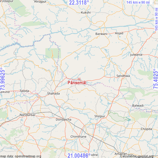
Pānsemāl GPS coordinates[2]
21° 39' 35.316" North, 74° 41' 57.732" East
| Map corner | latitude | longitude |
|---|---|---|
| Upper-left | 22.3118°, | 73.99625° |
| Center: | 21.65981°, | 74.69937° |
| Lower-right: | 21.00486°, | 75.4025° |
| Map W x H: | 145.3×145.3 km | = 90.3×90.3mi |
| max Lat: | 34.9274° ⇑58.2% North |
| Pānsemāl: | 21.65981° |
| min Lat: | ⇓41.8% South 8.09008° |
| min Long | Pānsemāl | max Long |
| 68.82655° | 74.69937° | 96.81° |
| W 14.7%⇐ | ⇒85.3% E |
Elevation
Elevation of Pānsemāl is 243 m = 797 ft, and this is 52.6 m = 173 ft below average elevation for this country.
| Max E: |
3681 m = 12077 ft | 41.4% |
| Avg. | 295.6 m = 970 ft | |
| Pānsemāl | 243 m = 797 ft | |
Min E: |
1 m = 3 ft | 58.6% |
See also: India elevation on elevation.city.
Geographical zone
Pānsemāl is located in North Torrid zone (between Equator and Tropic of Cancer). Distance of this Northern Tropic circle is 197.6 km =122.8 mi to North.| Distance of | km | miles | from Pānsemāl |
|---|---|---|---|
| North Pole | 7598.7 | 4721.6 | to North |
| Arctic Circle | 4992.8 | 3102.4 | to North |
| Tropic Cancer | 197.6 | 122.8 | to North |
| Equator | 2408.3 | 1496.4 | to South |


Nearby cities:
15 places around Pānsemāl: (largest is in red/bold)
• Amalner
78.3 km =48.7 mi,  151°
151°
• Anjad
56.1 km =34.9 mi,  40°
40°
• Barwāni
46.3 km =28.8 mi,  26°
26°
• Bāg
78.3 km =48.7 mi,  6°
6°
• Chopda
77.3 km =48 mi,  126°
126°
• Dondaicha
39.8 km =24.7 mi,  199°
199°
• Khetia
11.9 km =7.4 mi,  276°
276°
• Kukshi
61.1 km =38 mi, 5°
• Manāwar
75.6 km =47 mi, 32°
• Nandurbar
57.6 km =35.8 mi,  235°
235°
• Rajpur
54.8 km =34.1 mi,  55°
55°
• Sendhwa
41.1 km =25.5 mi,  85°
85°
• Shirpur
39.4 km =24.5 mi, 151°
• Shāhāda
26.8 km =16.7 mi, 241°
• Taloda
51.5 km =32 mi,  257°
257°
Sources, notices
• [Note1] Compared only with cities in India existing in our database
• [Src1] Map data: © OpenStreetMap contributors (CC-BY-SA)
• [Src2] Other city data from geonames.org with taken over terms of usage.
• [Src3] Geographical zone / Annual Mean Temperature by Robert A. Rohde @ Wikipedia
