Khetia geodata
Khetia (Maharashtra) is a populated place; located in India in Asia/Kolkata (GMT+5.5) time zone. With population of 15,021 people, there are 2460 cities with bigger population in this country. Compared to other cities in India, 58.2% of cities are located further ↑North; 86.1% of cities are located further →East and 52.3% of cities have lower elevation than Khetia. Note1


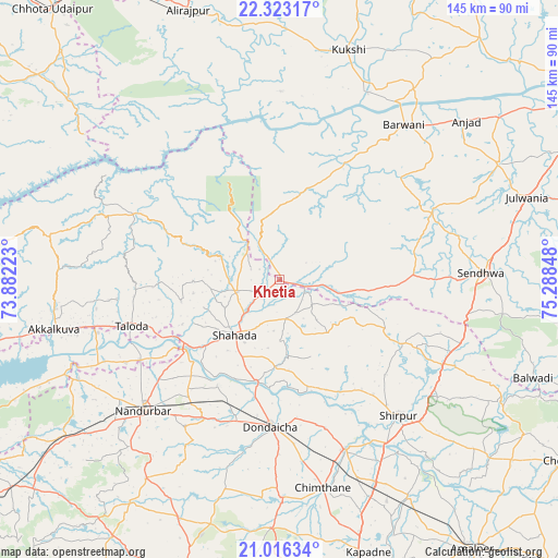
Khetia GPS coordinates[2]
21° 40' 16.464" North, 74° 35' 7.26" East
| Map corner | latitude | longitude |
|---|---|---|
| Upper-left | 22.32317°, | 73.88223° |
| Center: | 21.67124°, | 74.58535° |
| Lower-right: | 21.01634°, | 75.28848° |
| Map W x H: | 145.3×145.3 km | = 90.3×90.3mi |
| max Lat: | 34.9274° ⇑58.2% North |
| Khetia: | 21.67124° |
| min Lat: | ⇓41.8% South 8.09008° |
| min Long | Khetia | max Long |
| 68.82655° | 74.58535° | 96.81° |
| W 13.9%⇐ | ⇒86.1% E |
Elevation
Elevation of Khetia is 214 m = 702 ft, and this is 81.6 m = 268 ft below average elevation for this country.
| Max E: |
3681 m = 12077 ft | 47.7% |
| Avg. | 295.6 m = 970 ft | |
| Khetia | 214 m = 702 ft | |
Min E: |
1 m = 3 ft | 52.3% |
See also: India elevation on elevation.city.
Geographical zone
Khetia is located in North Torrid zone (between Equator and Tropic of Cancer). Distance of this Northern Tropic circle is 196.3 km =122 mi to North.| Distance of | km | miles | from Khetia |
|---|---|---|---|
| North Pole | 7597.4 | 4720.8 | to North |
| Arctic Circle | 4991.6 | 3101.6 | to North |
| Tropic Cancer | 196.3 | 122 | to North |
| Equator | 2409.6 | 1497.3 | to South |


Nearby cities:
15 places around Khetia: (largest is in red/bold)
• Anjad
63.6 km =39.5 mi,  49°
49°
• Barwāni
51.6 km =32.1 mi,  38°
38°
• Bāg
79.3 km =49.3 mi,  15°
15°
• Dondaicha
38.7 km =24 mi,  182°
182°
• Kawānt
72.4 km =45 mi,  310°
310°
• Kukshi
62.1 km =38.6 mi, 16°
• Manāwar
81.5 km =50.6 mi, 39°
• Nandurbar
49.2 km =30.6 mi,  226°
226°
• Pānsemāl
11.9 km =7.4 mi,  96°
96°
• Rajpur
64.2 km =39.9 mi,  62°
62°
• Rajpur
74.2 km =46.1 mi,  341°
341°
• Sendhwa
52.8 km =32.8 mi,  88°
88°
• Shirpur
47.1 km =29.3 mi,  139°
139°
• Shāhāda
18.3 km =11.4 mi,  220°
220°
• Taloda
40.4 km =25.1 mi,  252°
252°
Sources, notices
• [Note1] Compared only with cities in India existing in our database
• [Src1] Map data: © OpenStreetMap contributors (CC-BY-SA)
• [Src2] Other city data from geonames.org with taken over terms of usage.
• [Src3] Geographical zone / Annual Mean Temperature by Robert A. Rohde @ Wikipedia
