Shirpur geodata
Shirpur (Maharashtra) is a populated place; located in India in Asia/Kolkata (GMT+5.5) time zone. With population of 69,540 people, there are 624 cities with bigger population in this country. Compared to other cities in India, 59.7% of cities are located further ↑North; 83.7% of cities are located further →East and 58.3% of cities have higher elevation than Shirpur. Note1


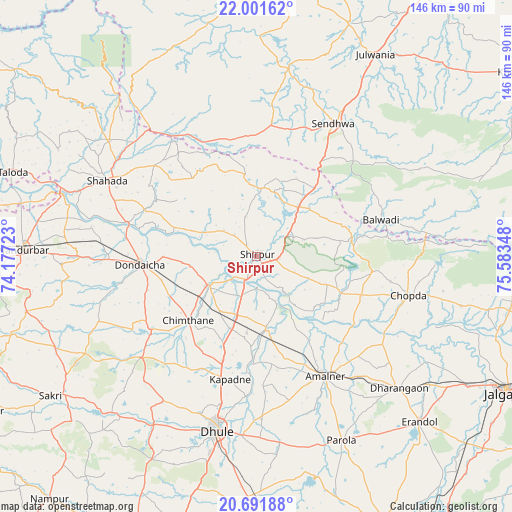
Shirpur GPS coordinates[2]
21° 20' 53.556" North, 74° 52' 49.26" East
| Map corner | latitude | longitude |
|---|---|---|
| Upper-left | 22.00162°, | 74.17723° |
| Center: | 21.34821°, | 74.88035° |
| Lower-right: | 20.69188°, | 75.58348° |
| Map W x H: | 145.6×145.6 km | = 90.5×90.5mi |
| max Lat: | 34.9274° ⇑59.7% North |
| Shirpur: | 21.34821° |
| min Lat: | ⇓40.3% South 8.09008° |
| min Long | Shirpur | max Long |
| 68.82655° | 74.88035° | 96.81° |
| W 16.3%⇐ | ⇒83.7% E |
Elevation
Elevation of Shirpur is 157 m = 515 ft, and this is 138.6 m = 455 ft below average elevation for this country.
| Max E: |
3681 m = 12077 ft | 58.3% |
| Avg. | 295.6 m = 970 ft | |
| Shirpur | 157 m = 515 ft | |
Min E: |
1 m = 3 ft | 41.7% |
See also: Shirpur elevation on elevation.city.
Geographical zone
Shirpur is located in North Torrid zone (between Equator and Tropic of Cancer). Distance of this Northern Tropic circle is 232.2 km =144.3 mi to North.| Distance of | km | miles | from Shirpur |
|---|---|---|---|
| North Pole | 7633.4 | 4743.2 | to North |
| Arctic Circle | 5027.5 | 3123.9 | to North |
| Tropic Cancer | 232.2 | 144.3 | to North |
| Equator | 2373.7 | 1474.9 | to South |


Nearby cities:
15 places around Shirpur: (largest is in red/bold)
• Amalner
39 km =24.2 mi,  151°
151°
• Barwāni
76.1 km =47.3 mi,  1°
1°
• Chopda
44.9 km =27.9 mi,  104°
104°
• Dharangaon
55.4 km =34.4 mi,  132°
132°
• Dhūlia
50.8 km =31.6 mi,  192°
192°
• Dondaicha
32.5 km =20.2 mi,  265°
265°
• Erandol
66.2 km =41.1 mi,  135°
135°
• Khetia
47.1 km =29.3 mi,  319°
319°
• Nandurbar
66.3 km =41.2 mi, 271°
• Parola
57.6 km =35.8 mi, 154°
• Pānsemāl
39.4 km =24.5 mi,  331°
331°
• Rajpur
70.9 km =44.1 mi,  21°
21°
• Sendhwa
43.7 km =27.2 mi,  30°
30°
• Shāhāda
47.7 km =29.6 mi,  297°
297°
• Taloda
73.1 km =45.4 mi,  288°
288°
Sources, notices
• [Note1] Compared only with cities in India existing in our database
• [Src1] Map data: © OpenStreetMap contributors (CC-BY-SA)
• [Src2] Other city data from geonames.org with taken over terms of usage.
• [Src3] Geographical zone / Annual Mean Temperature by Robert A. Rohde @ Wikipedia
