Kukshi geodata
Kukshi (Madhya Pradesh) is a populated place; located in India in Asia/Kolkata (GMT+5.5) time zone. With population of 26,183 people, there are 1629 cities with bigger population in this country. Compared to other cities in India, 55.2% of cities are located further ↑North; 84.8% of cities are located further →East and 54.8% of cities have higher elevation than Kukshi. Note1


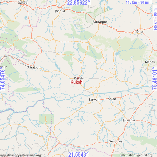
Kukshi GPS coordinates[2]
22° 12' 24.372" North, 74° 45' 28.368" East
| Map corner | latitude | longitude |
|---|---|---|
| Upper-left | 22.85622°, | 74.05476° |
| Center: | 22.20677°, | 74.75788° |
| Lower-right: | 21.5543°, | 75.46101° |
| Map W x H: | 144.8×144.8 km | = 90×90mi |
| max Lat: | 34.9274° ⇑55.2% North |
| Kukshi: | 22.20677° |
| min Lat: | ⇓44.8% South 8.09008° |
| min Long | Kukshi | max Long |
| 68.82655° | 74.75788° | 96.81° |
| W 15.2%⇐ | ⇒84.8% E |
Elevation
Elevation of Kukshi is 176 m = 577 ft, and this is 119.6 m = 392 ft below average elevation for this country.
| Max E: |
3681 m = 12077 ft | 54.8% |
| Avg. | 295.6 m = 970 ft | |
| Kukshi | 176 m = 577 ft | |
Min E: |
1 m = 3 ft | 45.2% |
See also: India elevation on elevation.city.
Geographical zone
Kukshi is located in North Torrid zone (between Equator and Tropic of Cancer). Distance of this Northern Tropic circle is 136.8 km =85 mi to North.| Distance of | km | miles | from Kukshi |
|---|---|---|---|
| North Pole | 7537.9 | 4683.8 | to North |
| Arctic Circle | 4932 | 3064.6 | to North |
| Tropic Cancer | 136.8 | 85 | to North |
| Equator | 2469.2 | 1534.3 | to South |


Nearby cities:
15 places around Kukshi: (largest is in red/bold)
• Anjad
35.7 km =22.2 mi,  120°
120°
• Barwāni
24.3 km =15.1 mi,  142°
142°
• Bhābhra
57 km =35.4 mi,  309°
309°
• Bāg
17.3 km =10.7 mi,  11°
11°
• Dharampuri
60.7 km =37.7 mi,  96°
96°
• Jhābua
64.7 km =40.2 mi,  344°
344°
• Jobat
30.4 km =18.9 mi,  320°
320°
• Khetia
62.1 km =38.6 mi,  196°
196°
• Manāwar
34.3 km =21.3 mi,  84°
84°
• Pānsemāl
61.1 km =38 mi,  185°
185°
• Rajpur
42.8 km =26.6 mi,  284°
284°
• Rajpur
49 km =30.4 mi,  127°
127°
• Rājgarh
55.8 km =34.7 mi,  20°
20°
• Rānāpur
54.7 km =34 mi,  333°
333°
• Sendhwa
67.6 km =42 mi,  148°
148°
Sources, notices
• [Note1] Compared only with cities in India existing in our database
• [Src1] Map data: © OpenStreetMap contributors (CC-BY-SA)
• [Src2] Other city data from geonames.org with taken over terms of usage.
• [Src3] Geographical zone / Annual Mean Temperature by Robert A. Rohde @ Wikipedia
