Hamīrpur geodata
Hamīrpur (Uttar Pradesh) is a populated place; located in India in Asia/Kolkata (GMT+5.5) time zone. With population of 34,144 people, there are 1272 cities with bigger population in this country. Compared to other cities in India, 70% of cities are located further ↓South; 69% of cities are located further ←West and 65.8% of cities have higher elevation than Hamīrpur. Note1


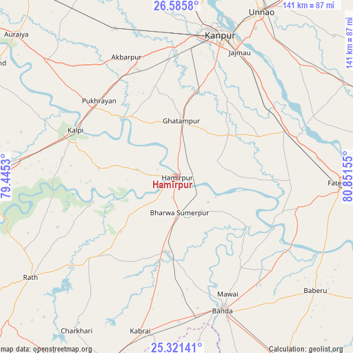
Hamīrpur GPS coordinates[2]
25° 57' 19.08" North, 80° 8' 54.312" East
| Map corner | latitude | longitude |
|---|---|---|
| Upper-left | 26.5858°, | 79.4453° |
| Center: | 25.9553°, | 80.14842° |
| Lower-right: | 25.32141°, | 80.85155° |
| Map W x H: | 140.6×140.6 km | = 87.4×87.4mi |
| max Lat: | 34.9274° ⇑30% North |
| Hamīrpur: | 25.9553° |
| min Lat: | ⇓70% South 8.09008° |
| min Long | Hamīrpur | max Long |
| 68.82655° | 80.14842° | 96.81° |
| W 69%⇐ | ⇒31% E |
Elevation
Elevation of Hamīrpur is 115 m = 377 ft, and this is 180.6 m = 593 ft below average elevation for this country.
| Max E: |
3681 m = 12077 ft | 65.8% |
| Avg. | 295.6 m = 970 ft | |
| Hamīrpur | 115 m = 377 ft | |
Min E: |
1 m = 3 ft | 34.2% |
See also: India elevation on elevation.city.
Geographical zone
Hamīrpur is located in North temperate zone (between Tropic of Cancer and the Arctic Circle). Distance of this Northern Tropic circle is 280 km =174 mi to South.| Distance of | km | miles | from Hamīrpur |
|---|---|---|---|
| North Pole | 7121.1 | 4424.8 | to North |
| Arctic Circle | 4515.2 | 2805.6 | to North |
| Tropic Cancer | 280 | 174 | to South |
| Equator | 2886 | 1793.3 | to South |


Nearby cities:
15 places around Hamīrpur: (largest is in red/bold)
• Akbarpur
51.6 km =32.1 mi,  337°
337°
• Bahua
49.1 km =30.5 mi,  105°
105°
• Bindki
43.7 km =27.2 mi,  78°
78°
• Bānda
56.3 km =35 mi,  160°
160°
• Ghātampur
22 km =13.7 mi,  5°
5°
• Kadaura
31.2 km =19.4 mi,  276°
276°
• Kanpur
60.2 km =37.4 mi,  19°
19°
• Kharela
56.9 km =35.4 mi,  216°
216°
• Kurāra
16.1 km =10 mi, 280°
• Kālpi
45.2 km =28.1 mi,  293°
293°
• Mataundh
57.8 km =35.9 mi,  179°
179°
• Maudaha
30.5 km =19 mi,  186°
186°
• Pukhrāyān
43.1 km =26.8 mi,  313°
313°
• Sarīla
51.4 km =31.9 mi,  247°
247°
• Tindwāri
53.4 km =33.2 mi,  134°
134°
Sources, notices
• [Note1] Compared only with cities in India existing in our database
• [Src1] Map data: © OpenStreetMap contributors (CC-BY-SA)
• [Src2] Other city data from geonames.org with taken over terms of usage.
• [Src3] Geographical zone / Annual Mean Temperature by Robert A. Rohde @ Wikipedia
