Maudaha geodata
Maudaha (Uttar Pradesh) is a populated place; located in India in Asia/Kolkata (GMT+5.5) time zone. With population of 37,844 people, there are 1165 cities with bigger population in this country. Compared to other cities in India, 68.3% of cities are located further ↓South; 68.7% of cities are located further ←West and 64% of cities have higher elevation than Maudaha. Note1


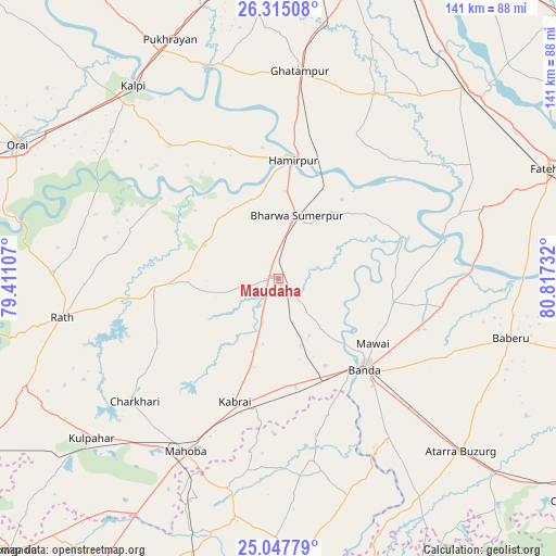
Maudaha GPS coordinates[2]
25° 40' 59.232" North, 80° 6' 51.084" East
| Map corner | latitude | longitude |
|---|---|---|
| Upper-left | 26.31508°, | 79.41107° |
| Center: | 25.68312°, | 80.11419° |
| Lower-right: | 25.04779°, | 80.81732° |
| Map W x H: | 140.9×140.9 km | = 87.6×87.6mi |
| max Lat: | 34.9274° ⇑31.7% North |
| Maudaha: | 25.68312° |
| min Lat: | ⇓68.3% South 8.09008° |
| min Long | Maudaha | max Long |
| 68.82655° | 80.11419° | 96.81° |
| W 68.7%⇐ | ⇒31.3% E |
Elevation
Elevation of Maudaha is 127 m = 417 ft, and this is 168.6 m = 553 ft below average elevation for this country.
| Max E: |
3681 m = 12077 ft | 64% |
| Avg. | 295.6 m = 970 ft | |
| Maudaha | 127 m = 417 ft | |
Min E: |
1 m = 3 ft | 36% |
See also: India elevation on elevation.city.
Geographical zone
Maudaha is located in North temperate zone (between Tropic of Cancer and the Arctic Circle). Distance of this Northern Tropic circle is 249.8 km =155.2 mi to South.| Distance of | km | miles | from Maudaha |
|---|---|---|---|
| North Pole | 7151.4 | 4443.7 | to North |
| Arctic Circle | 4545.5 | 2824.4 | to North |
| Tropic Cancer | 249.8 | 155.2 | to South |
| Equator | 2855.7 | 1774.4 | to South |


Nearby cities:
15 places around Maudaha: (largest is in red/bold)
• Bahua
53.8 km =33.4 mi,  71°
71°
• Bānda
31.8 km =19.8 mi,  135°
135°
• Charkhāri
48.1 km =29.9 mi,  229°
229°
• Ghātampur
52.5 km =32.6 mi,  5°
5°
• Gohānd
57 km =35.4 mi,  271°
271°
• Hamīrpur
30.5 km =19 mi, 6°
• Kabrāi
33.2 km =20.6 mi,  200°
200°
• Kadaura
43.5 km =27 mi,  320°
320°
• Kharela
34.1 km =21.2 mi,  242°
242°
• Kurāra
35.3 km =21.9 mi,  339°
339°
• Mahobā
49.8 km =30.9 mi,  208°
208°
• Mataundh
27.8 km =17.3 mi,  171°
171°
• Rāth
55.8 km =34.7 mi,  259°
259°
• Sarīla
45.1 km =28 mi,  283°
283°
• Tindwāri
42 km =26.1 mi,  100°
100°
Sources, notices
• [Note1] Compared only with cities in India existing in our database
• [Src1] Map data: © OpenStreetMap contributors (CC-BY-SA)
• [Src2] Other city data from geonames.org with taken over terms of usage.
• [Src3] Geographical zone / Annual Mean Temperature by Robert A. Rohde @ Wikipedia
