Charkhāri geodata
Charkhāri (Uttar Pradesh) is a populated place; located in India in Asia/Kolkata (GMT+5.5) time zone. With population of 24,881 people, there are 1714 cities with bigger population in this country. Compared to other cities in India, 66.1% of cities are located further ↓South; 66.2% of cities are located further ←West and 50.8% of cities have higher elevation than Charkhāri. Note1


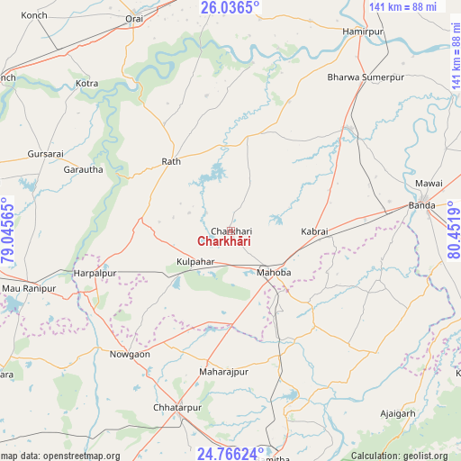
Charkhāri GPS coordinates[2]
25° 24' 10.944" North, 79° 44' 55.572" East
| Map corner | latitude | longitude |
|---|---|---|
| Upper-left | 26.0365°, | 79.04565° |
| Center: | 25.40304°, | 79.74877° |
| Lower-right: | 24.76624°, | 80.4519° |
| Map W x H: | 141.2×141.2 km | = 87.7×87.7mi |
| max Lat: | 34.9274° ⇑33.9% North |
| Charkhāri: | 25.40304° |
| min Lat: | ⇓66.1% South 8.09008° |
| min Long | Charkhāri | max Long |
| 68.82655° | 79.74877° | 96.81° |
| W 66.2%⇐ | ⇒33.8% E |
Elevation
Elevation of Charkhāri is 198 m = 650 ft, and this is 97.6 m = 320 ft below average elevation for this country.
| Max E: |
3681 m = 12077 ft | 50.8% |
| Avg. | 295.6 m = 970 ft | |
| Charkhāri | 198 m = 650 ft | |
Min E: |
1 m = 3 ft | 49.2% |
See also: India elevation on elevation.city.
Geographical zone
Charkhāri is located in North temperate zone (between Tropic of Cancer and the Arctic Circle). Distance of this Northern Tropic circle is 218.6 km =135.8 mi to South.| Distance of | km | miles | from Charkhāri |
|---|---|---|---|
| North Pole | 7182.5 | 4463 | to North |
| Arctic Circle | 4576.6 | 2843.8 | to North |
| Tropic Cancer | 218.6 | 135.8 | to South |
| Equator | 2824.6 | 1755.1 | to South |


Nearby cities:
15 places around Charkhāri: (largest is in red/bold)
• Bānda
59.4 km =36.9 mi,  81°
81°
• Chandla
57.9 km =36 mi,  129°
129°
• Chhatarpur
56.3 km =35 mi,  196°
196°
• Garautha
49 km =30.4 mi,  292°
292°
• Gohānd
38.7 km =24 mi,  328°
328°
• Harpālpur
43.7 km =27.2 mi,  252°
252°
• Kabrāi
25.2 km =15.7 mi,  90°
90°
• Kharela
16.8 km =10.4 mi,  22°
22°
• Kulpahār
14.4 km =8.9 mi,  230°
230°
• Mahobā
17.8 km =11.1 mi, 134°
• Mataundh
41.1 km =25.5 mi, 84°
• Maudaha
48.1 km =29.9 mi,  49°
49°
• Rājnagar
59.4 km =36.9 mi,  163°
163°
• Rāth
28.1 km =17.5 mi,  319°
319°
• Sarīla
42.1 km =26.2 mi,  349°
349°
Sources, notices
• [Note1] Compared only with cities in India existing in our database
• [Src1] Map data: © OpenStreetMap contributors (CC-BY-SA)
• [Src2] Other city data from geonames.org with taken over terms of usage.
• [Src3] Geographical zone / Annual Mean Temperature by Robert A. Rohde @ Wikipedia
