Kulpahār geodata
Kulpahār (Uttar Pradesh) is a populated place; located in India in Asia/Kolkata (GMT+5.5) time zone. With population of 18,976 people, there are 2128 cities with bigger population in this country. Compared to other cities in India, 65.4% of cities are located further ↓South; 65.1% of cities are located further ←West and 50.8% of cities have higher elevation than Kulpahār. Note1


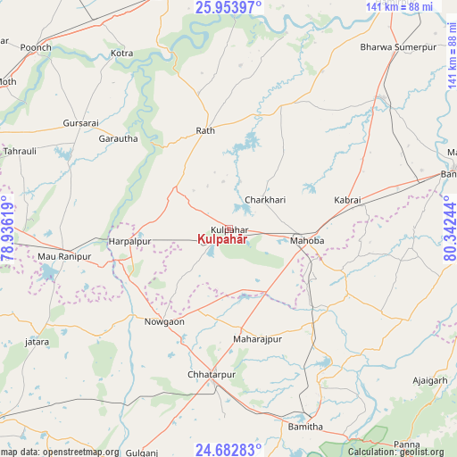
Kulpahār GPS coordinates[2]
25° 19' 12.252" North, 79° 38' 21.516" East
| Map corner | latitude | longitude |
|---|---|---|
| Upper-left | 25.95397°, | 78.93619° |
| Center: | 25.32007°, | 79.63931° |
| Lower-right: | 24.68283°, | 80.34244° |
| Map W x H: | 141.3×141.3 km | = 87.8×87.8mi |
| max Lat: | 34.9274° ⇑34.6% North |
| Kulpahār: | 25.32007° |
| min Lat: | ⇓65.4% South 8.09008° |
| min Long | Kulpahār | max Long |
| 68.82655° | 79.63931° | 96.81° |
| W 65.1%⇐ | ⇒34.9% E |
Elevation
Elevation of Kulpahār is 198 m = 650 ft, and this is 97.6 m = 320 ft below average elevation for this country.
| Max E: |
3681 m = 12077 ft | 50.8% |
| Avg. | 295.6 m = 970 ft | |
| Kulpahār | 198 m = 650 ft | |
Min E: |
1 m = 3 ft | 49.2% |
See also: India elevation on elevation.city.
Geographical zone
Kulpahār is located in North temperate zone (between Tropic of Cancer and the Arctic Circle). Distance of this Northern Tropic circle is 209.4 km =130.1 mi to South.| Distance of | km | miles | from Kulpahār |
|---|---|---|---|
| North Pole | 7191.7 | 4468.7 | to North |
| Arctic Circle | 4585.8 | 2849.5 | to North |
| Tropic Cancer | 209.4 | 130.1 | to South |
| Equator | 2815.3 | 1749.3 | to South |


Nearby cities:
15 places around Kulpahār: (largest is in red/bold)
• Charkhāri
14.4 km =8.9 mi,  50°
50°
• Chhatarpur
45 km =28 mi,  186°
186°
• Garautha
44.3 km =27.5 mi,  309°
309°
• Gohānd
43.1 km =26.8 mi,  347°
347°
• Gursarāi
56.7 km =35.2 mi, 305°
• Harpālpur
31 km =19.3 mi,  263°
263°
• Kabrāi
37.4 km =23.2 mi,  75°
75°
• Kharela
30.3 km =18.8 mi,  35°
35°
• Mahobā
24 km =14.9 mi,  97°
97°
• Mataundh
53.5 km =33.2 mi, 76°
• Palera
53.1 km =33 mi,  231°
231°
• Rājnagar
55.2 km =34.3 mi,  150°
150°
• Rāth
31.4 km =19.5 mi, 346°
• Sarīla
50.8 km =31.6 mi,  4°
4°
• Tori-Fatehpur
54.8 km =34.1 mi,  285°
285°
Sources, notices
• [Note1] Compared only with cities in India existing in our database
• [Src1] Map data: © OpenStreetMap contributors (CC-BY-SA)
• [Src2] Other city data from geonames.org with taken over terms of usage.
• [Src3] Geographical zone / Annual Mean Temperature by Robert A. Rohde @ Wikipedia
