Bahsūma geodata
Bahsūma (Uttar Pradesh) is a populated place; located in India in Asia/Kolkata (GMT+5.5) time zone. With population of 11,157 people, there are 2820 cities with bigger population in this country. Compared to other cities in India, 89.8% of cities are located further ↓South; 51.6% of cities are located further →East and 57.4% of cities have lower elevation than Bahsūma. Note1


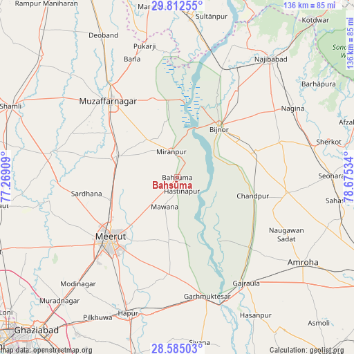
Bahsūma GPS coordinates[2]
29° 12' 2.268" North, 77° 58' 19.956" East
| Map corner | latitude | longitude |
|---|---|---|
| Upper-left | 29.81255°, | 77.26909° |
| Center: | 29.20063°, | 77.97221° |
| Lower-right: | 28.58503°, | 78.67534° |
| Map W x H: | 136.5×136.5 km | = 84.8×84.8mi |
| max Lat: | 34.9274° ⇑10.2% North |
| Bahsūma: | 29.20063° |
| min Lat: | ⇓89.8% South 8.09008° |
| min Long | Bahsūma | max Long |
| 68.82655° | 77.97221° | 96.81° |
| W 48.4%⇐ | ⇒51.6% E |
Elevation
Elevation of Bahsūma is 236 m = 774 ft, and this is 59.6 m = 196 ft below average elevation for this country.
| Max E: |
3681 m = 12077 ft | 42.6% |
| Avg. | 295.6 m = 970 ft | |
| Bahsūma | 236 m = 774 ft | |
Min E: |
1 m = 3 ft | 57.4% |
See also: India elevation on elevation.city.
Geographical zone
Bahsūma is located in North temperate zone (between Tropic of Cancer and the Arctic Circle). Distance of this Northern Tropic circle is 640.9 km =398.2 mi to South.| Distance of | km | miles | from Bahsūma |
|---|---|---|---|
| North Pole | 6760.3 | 4200.7 | to North |
| Arctic Circle | 4154.4 | 2581.4 | to North |
| Tropic Cancer | 640.9 | 398.2 | to South |
| Equator | 3246.8 | 2017.5 | to South |


Nearby cities:
15 places around Bahsūma: (largest is in red/bold)
• Bijnor
24.9 km =15.5 mi,  39°
39°
• Chāndpur
30 km =18.6 mi,  104°
104°
• Daurāla
27.7 km =17.2 mi,  249°
249°
• Haldaur
31.9 km =19.8 mi,  71°
71°
• Hastināpur
5.6 km =3.5 mi,  142°
142°
• Jhālu
28.9 km =18 mi,  58°
58°
• Jānsath
18.2 km =11.3 mi,  319°
319°
• Khatauli
24.8 km =15.4 mi,  290°
290°
• Lāwar Khās
21.4 km =13.3 mi,  242°
242°
• Mandāwar
35.2 km =21.9 mi,  25°
25°
• Mawāna
11.9 km =7.4 mi,  204°
204°
• Mīrānpur
10.2 km =6.3 mi,  347°
347°
• Parīchhatgarh
25 km =15.5 mi,  188°
188°
• Phalauda
13.9 km =8.6 mi,  264°
264°
• Sardhana
35.3 km =21.9 mi, 259°
Sources, notices
• [Note1] Compared only with cities in India existing in our database
• [Src1] Map data: © OpenStreetMap contributors (CC-BY-SA)
• [Src2] Other city data from geonames.org with taken over terms of usage.
• [Src3] Geographical zone / Annual Mean Temperature by Robert A. Rohde @ Wikipedia
