Niwāri geodata
Niwāri (Uttar Pradesh) is a populated place; located in India in Asia/Kolkata (GMT+5.5) time zone. With population of 10,330 people, there are 2909 cities with bigger population in this country. Compared to other cities in India, 88.6% of cities are located further ↓South; 56.8% of cities are located further →East and 54.7% of cities have lower elevation than Niwāri. Note1


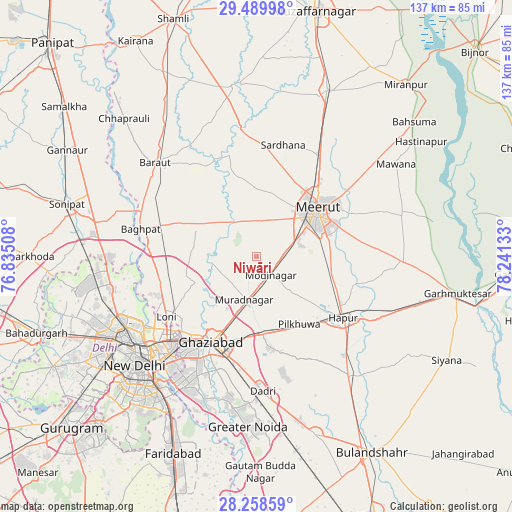
Niwāri GPS coordinates[2]
28° 52' 33.996" North, 77° 32' 17.52" East
| Map corner | latitude | longitude |
|---|---|---|
| Upper-left | 29.48998°, | 76.83508° |
| Center: | 28.87611°, | 77.5382° |
| Lower-right: | 28.25859°, | 78.24133° |
| Map W x H: | 136.9×136.9 km | = 85.1×85.1mi |
| max Lat: | 34.9274° ⇑11.4% North |
| Niwāri: | 28.87611° |
| min Lat: | ⇓88.6% South 8.09008° |
| min Long | Niwāri | max Long |
| 68.82655° | 77.5382° | 96.81° |
| W 43.2%⇐ | ⇒56.8% E |
Elevation
Elevation of Niwāri is 225 m = 738 ft, and this is 70.6 m = 232 ft below average elevation for this country.
| Max E: |
3681 m = 12077 ft | 45.3% |
| Avg. | 295.6 m = 970 ft | |
| Niwāri | 225 m = 738 ft | |
Min E: |
1 m = 3 ft | 54.7% |
See also: India elevation on elevation.city.
Geographical zone
Niwāri is located in North temperate zone (between Tropic of Cancer and the Arctic Circle). Distance of this Northern Tropic circle is 604.8 km =375.8 mi to South.| Distance of | km | miles | from Niwāri |
|---|---|---|---|
| North Pole | 6796.3 | 4223 | to North |
| Arctic Circle | 4190.5 | 2603.9 | to North |
| Tropic Cancer | 604.8 | 375.8 | to South |
| Equator | 3210.7 | 1995 | to South |


Nearby cities:
15 places around Niwāri: (largest is in red/bold)
• Babugarh
34.5 km =21.4 mi,  119°
119°
• Bāghpat
32 km =19.9 mi,  283°
283°
• Daurāla
31 km =19.3 mi,  31°
31°
• Dāsna
22.2 km =13.8 mi,  183°
183°
• Farīdnagar
14.8 km =9.2 mi,  143°
143°
• Ghāziābād
25.3 km =15.7 mi,  202°
202°
• Hāpur
28.7 km =17.8 mi, 124°
• Kharkhauda
20.3 km =12.6 mi,  102°
102°
• Khekra
24.8 km =15.4 mi,  267°
267°
• Loni
27.9 km =17.3 mi,  240°
240°
• Lāwar Khās
35 km =21.7 mi,  41°
41°
• Meerut
20 km =12.4 mi,  54°
54°
• Murādnagar
11.3 km =7 mi, 199°
• Pilkhua
21.5 km =13.4 mi,  147°
147°
• Sardhana
30.9 km =19.2 mi,  13°
13°
Sources, notices
• [Note1] Compared only with cities in India existing in our database
• [Src1] Map data: © OpenStreetMap contributors (CC-BY-SA)
• [Src2] Other city data from geonames.org with taken over terms of usage.
• [Src3] Geographical zone / Annual Mean Temperature by Robert A. Rohde @ Wikipedia
