Phalauda geodata
Phalauda (Uttar Pradesh) is a populated place; located in India in Asia/Kolkata (GMT+5.5) time zone. With population of 18,545 people, there are 2163 cities with bigger population in this country. Compared to other cities in India, 89.7% of cities are located further ↓South; 53.3% of cities are located further →East and 57.7% of cities have lower elevation than Phalauda. Note1


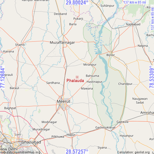
Phalauda GPS coordinates[2]
29° 11' 17.664" North, 77° 49' 47.856" East
| Map corner | latitude | longitude |
|---|---|---|
| Upper-left | 29.80024°, | 77.12684° |
| Center: | 29.18824°, | 77.82996° |
| Lower-right: | 28.57257°, | 78.53309° |
| Map W x H: | 136.5×136.5 km | = 84.8×84.8mi |
| max Lat: | 34.9274° ⇑10.3% North |
| Phalauda: | 29.18824° |
| min Lat: | ⇓89.7% South 8.09008° |
| min Long | Phalauda | max Long |
| 68.82655° | 77.82996° | 96.81° |
| W 46.7%⇐ | ⇒53.3% E |
Elevation
Elevation of Phalauda is 238 m = 781 ft, and this is 57.6 m = 189 ft below average elevation for this country.
| Max E: |
3681 m = 12077 ft | 42.3% |
| Avg. | 295.6 m = 970 ft | |
| Phalauda | 238 m = 781 ft | |
Min E: |
1 m = 3 ft | 57.7% |
See also: India elevation on elevation.city.
Geographical zone
Phalauda is located in North temperate zone (between Tropic of Cancer and the Arctic Circle). Distance of this Northern Tropic circle is 639.5 km =397.4 mi to South.| Distance of | km | miles | from Phalauda |
|---|---|---|---|
| North Pole | 6761.6 | 4201.5 | to North |
| Arctic Circle | 4155.7 | 2582.2 | to North |
| Tropic Cancer | 639.5 | 397.4 | to South |
| Equator | 3245.4 | 2016.6 | to South |


Nearby cities:
15 places around Phalauda: (largest is in red/bold)
• Bahsūma
13.9 km =8.6 mi,  84°
84°
• Bijnor
36.1 km =22.4 mi,  55°
55°
• Budhāna
36.2 km =22.5 mi,  287°
287°
• Daurāla
14.7 km =9.1 mi,  235°
235°
• Hastināpur
17.5 km =10.9 mi,  100°
100°
• Jānsath
15.3 km =9.5 mi,  7°
7°
• Khatauli
13.7 km =8.5 mi,  316°
316°
• Lāwar Khās
10 km =6.2 mi,  210°
210°
• Mawāna
13 km =8.1 mi,  136°
136°
• Meerut
26.1 km =16.2 mi, 207°
• Muzaffarnagar
33.7 km =20.9 mi,  338°
338°
• Mīrānpur
16.2 km =10.1 mi,  45°
45°
• Parīchhatgarh
25.4 km =15.8 mi,  156°
156°
• Sardhana
21.5 km =13.4 mi,  257°
257°
• Shāhpur
32.4 km =20.1 mi,  303°
303°
Sources, notices
• [Note1] Compared only with cities in India existing in our database
• [Src1] Map data: © OpenStreetMap contributors (CC-BY-SA)
• [Src2] Other city data from geonames.org with taken over terms of usage.
• [Src3] Geographical zone / Annual Mean Temperature by Robert A. Rohde @ Wikipedia
