Lāwar Khās geodata
Lāwar Khās (Uttar Pradesh) is a populated place; located in India in Asia/Kolkata (GMT+5.5) time zone. With population of 19,556 people, there are 2071 cities with bigger population in this country. Compared to other cities in India, 89.3% of cities are located further ↓South; 54% of cities are located further →East and 58.1% of cities have lower elevation than Lāwar Khās. Note1


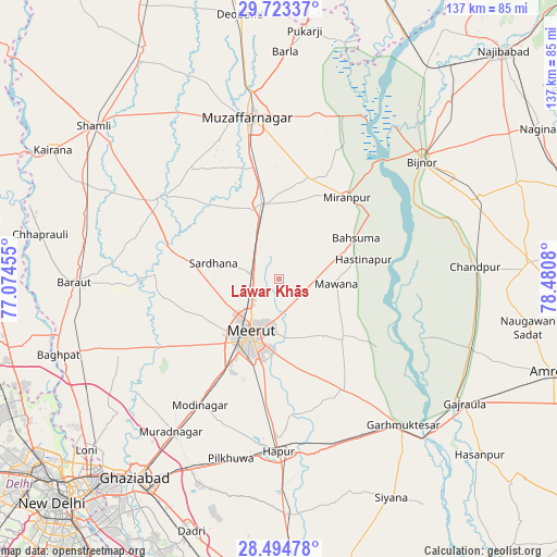
Lāwar Khās GPS coordinates[2]
29° 6' 39.276" North, 77° 46' 39.612" East
| Map corner | latitude | longitude |
|---|---|---|
| Upper-left | 29.72337°, | 77.07455° |
| Center: | 29.11091°, | 77.77767° |
| Lower-right: | 28.49478°, | 78.4808° |
| Map W x H: | 136.6×136.6 km | = 84.9×84.9mi |
| max Lat: | 34.9274° ⇑10.7% North |
| Lāwar Khās: | 29.11091° |
| min Lat: | ⇓89.3% South 8.09008° |
| min Long | Lāwar Khās | max Long |
| 68.82655° | 77.77767° | 96.81° |
| W 46%⇐ | ⇒54% E |
Elevation
Elevation of Lāwar Khās is 240 m = 787 ft, and this is 55.6 m = 182 ft below average elevation for this country.
| Max E: |
3681 m = 12077 ft | 41.9% |
| Avg. | 295.6 m = 970 ft | |
| Lāwar Khās | 240 m = 787 ft | |
Min E: |
1 m = 3 ft | 58.1% |
See also: India elevation on elevation.city.
Geographical zone
Lāwar Khās is located in North temperate zone (between Tropic of Cancer and the Arctic Circle). Distance of this Northern Tropic circle is 630.9 km =392 mi to South.| Distance of | km | miles | from Lāwar Khās |
|---|---|---|---|
| North Pole | 6770.2 | 4206.8 | to North |
| Arctic Circle | 4164.3 | 2587.6 | to North |
| Tropic Cancer | 630.9 | 392 | to South |
| Equator | 3236.8 | 2011.3 | to South |


Nearby cities:
15 places around Lāwar Khās: (largest is in red/bold)
• Bahsūma
21.4 km =13.3 mi,  62°
62°
• Daurāla
7.1 km =4.4 mi,  272°
272°
• Hastināpur
23 km =14.3 mi,  76°
76°
• Jānsath
24.8 km =15.4 mi,  16°
16°
• Kharkhauda
30.7 km =19.1 mi,  186°
186°
• Khatauli
19.1 km =11.9 mi,  346°
346°
• Kithor
31.3 km =19.4 mi,  150°
150°
• Mawāna
14 km =8.7 mi,  93°
93°
• Meerut
16.1 km =10 mi,  205°
205°
• Mīrānpur
26 km =16.2 mi,  39°
39°
• Niwāri
35 km =21.7 mi,  221°
221°
• Parīchhatgarh
21.2 km =13.2 mi,  134°
134°
• Phalauda
10 km =6.2 mi,  30°
30°
• Sardhana
16.3 km =10.1 mi,  283°
283°
• Shāhpur
34.5 km =21.4 mi,  320°
320°
Sources, notices
• [Note1] Compared only with cities in India existing in our database
• [Src1] Map data: © OpenStreetMap contributors (CC-BY-SA)
• [Src2] Other city data from geonames.org with taken over terms of usage.
• [Src3] Geographical zone / Annual Mean Temperature by Robert A. Rohde @ Wikipedia
