Bhīkhi geodata
Bhīkhi (Punjab) is a populated place; located in India in Asia/Kolkata (GMT+5.5) time zone. With population of 15,961 people, there are 2372 cities with bigger population in this country. Compared to other cities in India, 92.9% of cities are located further ↓South; 78.3% of cities are located further →East and 55.1% of cities have lower elevation than Bhīkhi. Note1


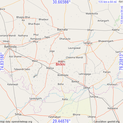
Bhīkhi GPS coordinates[2]
30° 3' 33.048" North, 75° 32' 6" East
| Map corner | latitude | longitude |
|---|---|---|
| Upper-left | 30.66586°, | 74.83188° |
| Center: | 30.05918°, | 75.535° |
| Lower-right: | 29.44876°, | 76.23813° |
| Map W x H: | 135.3×135.3 km | = 84.1×84.1mi |
| max Lat: | 34.9274° ⇑7.1% North |
| Bhīkhi: | 30.05918° |
| min Lat: | ⇓92.9% South 8.09008° |
| min Long | Bhīkhi | max Long |
| 68.82655° | 75.535° | 96.81° |
| W 21.7%⇐ | ⇒78.3% E |
Elevation
Elevation of Bhīkhi is 227 m = 745 ft, and this is 68.6 m = 225 ft below average elevation for this country.
| Max E: |
3681 m = 12077 ft | 44.9% |
| Avg. | 295.6 m = 970 ft | |
| Bhīkhi | 227 m = 745 ft | |
Min E: |
1 m = 3 ft | 55.1% |
See also: India elevation on elevation.city.
Geographical zone
Bhīkhi is located in North temperate zone (between Tropic of Cancer and the Arctic Circle). Distance of this Northern Tropic circle is 736.3 km =457.5 mi to South.| Distance of | km | miles | from Bhīkhi |
|---|---|---|---|
| North Pole | 6664.8 | 4141.3 | to North |
| Arctic Circle | 4058.9 | 2522.1 | to North |
| Tropic Cancer | 736.3 | 457.5 | to South |
| Equator | 3342.3 | 2076.8 | to South |


Nearby cities:
15 places around Bhīkhi: (largest is in red/bold)
• Akālgarh
43.3 km =26.9 mi,  127°
127°
• Barnāla
35.1 km =21.8 mi,  2°
2°
• Budhlāda
14.8 km =9.2 mi,  169°
169°
• Dhanaula
25.1 km =15.6 mi,  8°
8°
• Dhūri
47 km =29.2 mi,  42°
42°
• Dirba
44.4 km =27.6 mi,  88°
88°
• Jākhal
40.4 km =25.1 mi,  136°
136°
• Laungowāl
20.5 km =12.7 mi, 43°
• Maur
27.6 km =17.1 mi,  275°
275°
• Mānsa
15.1 km =9.4 mi,  238°
238°
• Ratia
41.2 km =25.6 mi, 174°
• Rāmpura
35.7 km =22.2 mi,  307°
307°
• Sangrūr
36.3 km =22.6 mi,  55°
55°
• Sardulgarh
50 km =31.1 mi,  215°
215°
• Sunām
26.6 km =16.5 mi,  73°
73°
Sources, notices
• [Note1] Compared only with cities in India existing in our database
• [Src1] Map data: © OpenStreetMap contributors (CC-BY-SA)
• [Src2] Other city data from geonames.org with taken over terms of usage.
• [Src3] Geographical zone / Annual Mean Temperature by Robert A. Rohde @ Wikipedia
