Budhlāda geodata
Budhlāda (Punjab) is a populated place; located in India in Asia/Kolkata (GMT+5.5) time zone. With population of 25,431 people, there are 1672 cities with bigger population in this country. Compared to other cities in India, 92.6% of cities are located further ↓South; 78% of cities are located further →East and 55.1% of cities have lower elevation than Budhlāda. Note1


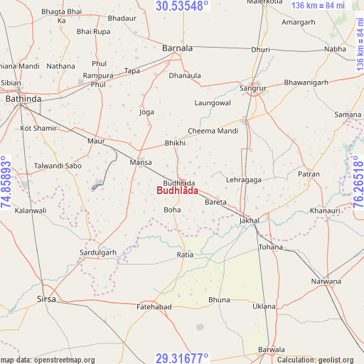
Budhlāda GPS coordinates[2]
29° 55' 40.764" North, 75° 33' 43.38" East
| Map corner | latitude | longitude |
|---|---|---|
| Upper-left | 30.53548°, | 74.85893° |
| Center: | 29.92799°, | 75.56205° |
| Lower-right: | 29.31677°, | 76.26518° |
| Map W x H: | 135.5×135.5 km | = 84.2×84.2mi |
| max Lat: | 34.9274° ⇑7.4% North |
| Budhlāda: | 29.92799° |
| min Lat: | ⇓92.6% South 8.09008° |
| min Long | Budhlāda | max Long |
| 68.82655° | 75.56205° | 96.81° |
| W 22%⇐ | ⇒78% E |
Elevation
Elevation of Budhlāda is 227 m = 745 ft, and this is 68.6 m = 225 ft below average elevation for this country.
| Max E: |
3681 m = 12077 ft | 44.9% |
| Avg. | 295.6 m = 970 ft | |
| Budhlāda | 227 m = 745 ft | |
Min E: |
1 m = 3 ft | 55.1% |
See also: India elevation on elevation.city.
Geographical zone
Budhlāda is located in North temperate zone (between Tropic of Cancer and the Arctic Circle). Distance of this Northern Tropic circle is 721.8 km =448.5 mi to South.| Distance of | km | miles | from Budhlāda |
|---|---|---|---|
| North Pole | 6679.4 | 4150.4 | to North |
| Arctic Circle | 4073.5 | 2531.2 | to North |
| Tropic Cancer | 721.8 | 448.5 | to South |
| Equator | 3327.7 | 2067.7 | to South |


Nearby cities:
15 places around Budhlāda: (largest is in red/bold)
• Akālgarh
33.9 km =21.1 mi,  110°
110°
• Bhīkhi
14.8 km =9.2 mi,  349°
349°
• Dhanaula
39.4 km =24.5 mi,  1°
1°
• Dirba
44.8 km =27.8 mi,  69°
69°
• Fatehābād
47 km =29.2 mi,  192°
192°
• Inda Chhoi
38.8 km =24.1 mi,  145°
145°
• Jākhal
29.2 km =18.1 mi,  120°
120°
• Laungowāl
31.7 km =19.7 mi,  21°
21°
• Maur
34.7 km =21.6 mi,  299°
299°
• Mānsa
16.8 km =10.4 mi,  293°
293°
• Ratia
26.5 km =16.5 mi,  176°
176°
• Sangrūr
44.5 km =27.7 mi,  37°
37°
• Sardulgarh
40.9 km =25.4 mi,  230°
230°
• Sunām
32 km =19.9 mi,  45°
45°
• Tohāna
40.7 km =25.3 mi,  125°
125°
Sources, notices
• [Note1] Compared only with cities in India existing in our database
• [Src1] Map data: © OpenStreetMap contributors (CC-BY-SA)
• [Src2] Other city data from geonames.org with taken over terms of usage.
• [Src3] Geographical zone / Annual Mean Temperature by Robert A. Rohde @ Wikipedia
