Akālgarh geodata
Akālgarh (Punjab) is a populated place; located in India in Asia/Kolkata (GMT+5.5) time zone. With population of 6,993 people, there are 3211 cities with bigger population in this country. Compared to other cities in India, 92.3% of cities are located further ↓South; 74.7% of cities are located further →East and 56.1% of cities have lower elevation than Akālgarh. Note1


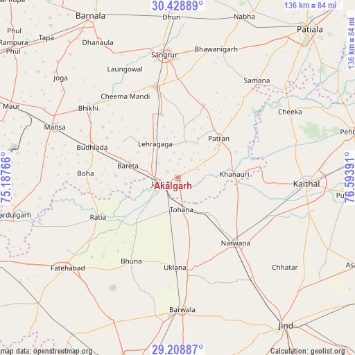
Akālgarh GPS coordinates[2]
29° 49' 14.664" North, 75° 53' 26.808" East
| Map corner | latitude | longitude |
|---|---|---|
| Upper-left | 30.42889°, | 75.18766° |
| Center: | 29.82074°, | 75.89078° |
| Lower-right: | 29.20887°, | 76.59391° |
| Map W x H: | 135.7×135.7 km | = 84.3×84.3mi |
| max Lat: | 34.9274° ⇑7.7% North |
| Akālgarh: | 29.82074° |
| min Lat: | ⇓92.3% South 8.09008° |
| min Long | Akālgarh | max Long |
| 68.82655° | 75.89078° | 96.81° |
| W 25.3%⇐ | ⇒74.7% E |
Elevation
Elevation of Akālgarh is 230 m = 755 ft, and this is 65.6 m = 215 ft below average elevation for this country.
| Max E: |
3681 m = 12077 ft | 43.9% |
| Avg. | 295.6 m = 970 ft | |
| Akālgarh | 230 m = 755 ft | |
Min E: |
1 m = 3 ft | 56.1% |
See also: India elevation on elevation.city.
Geographical zone
Akālgarh is located in North temperate zone (between Tropic of Cancer and the Arctic Circle). Distance of this Northern Tropic circle is 709.8 km =441 mi to South.| Distance of | km | miles | from Akālgarh |
|---|---|---|---|
| North Pole | 6691.3 | 4157.8 | to North |
| Arctic Circle | 4085.4 | 2538.5 | to North |
| Tropic Cancer | 709.8 | 441 | to South |
| Equator | 3315.8 | 2060.3 | to South |


Nearby cities:
15 places around Akālgarh: (largest is in red/bold)
• Bara Uchāna
48.1 km =29.9 mi,  144°
144°
• Bhīkhi
43.3 km =26.9 mi,  307°
307°
• Budhlāda
33.9 km =21.1 mi,  290°
290°
• Dirba
29.7 km =18.5 mi,  19°
19°
• Gorakhpur
46.6 km =29 mi,  207°
207°
• Inda Chhoi
22.3 km =13.9 mi, 205°
• Jākhal
7 km =4.3 mi,  247°
247°
• Kaithal
49.1 km =30.5 mi,  92°
92°
• Laungowāl
46.2 km =28.7 mi,  334°
334°
• Narwāna
33.1 km =20.6 mi, 138°
• Ratia
33.6 km =20.9 mi,  244°
244°
• Sangrūr
47.4 km =29.5 mi,  354°
354°
• Sunām
35.4 km =22 mi, 345°
• Tohāna
12 km =7.5 mi,  173°
173°
• Uklāna
34.4 km =21.4 mi,  182°
182°
Sources, notices
• [Note1] Compared only with cities in India existing in our database
• [Src1] Map data: © OpenStreetMap contributors (CC-BY-SA)
• [Src2] Other city data from geonames.org with taken over terms of usage.
• [Src3] Geographical zone / Annual Mean Temperature by Robert A. Rohde @ Wikipedia
