Seondha geodata
Seondha (Madhya Pradesh) is a populated place; located in India in Asia/Kolkata (GMT+5.5) time zone. With population of 21,326 people, there are 1949 cities with bigger population in this country. Compared to other cities in India, 71.7% of cities are located further ↓South; 56.6% of cities are located further ←West and 56.6% of cities have higher elevation than Seondha. Note1


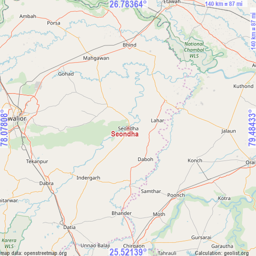
Seondha GPS coordinates[2]
26° 9' 15.192" North, 78° 46' 52.32" East
| Map corner | latitude | longitude |
|---|---|---|
| Upper-left | 26.78364°, | 78.07808° |
| Center: | 26.15422°, | 78.7812° |
| Lower-right: | 25.52139°, | 79.48433° |
| Map W x H: | 140.3×140.4 km | = 87.2×87.2mi |
| max Lat: | 34.9274° ⇑28.3% North |
| Seondha: | 26.15422° |
| min Lat: | ⇓71.7% South 8.09008° |
| min Long | Seondha | max Long |
| 68.82655° | 78.7812° | 96.81° |
| W 56.6%⇐ | ⇒43.4% E |
Elevation
Elevation of Seondha is 167 m = 548 ft, and this is 128.6 m = 422 ft below average elevation for this country.
| Max E: |
3681 m = 12077 ft | 56.6% |
| Avg. | 295.6 m = 970 ft | |
| Seondha | 167 m = 548 ft | |
Min E: |
1 m = 3 ft | 43.4% |
See also: India elevation on elevation.city.
Geographical zone
Seondha is located in North temperate zone (between Tropic of Cancer and the Arctic Circle). Distance of this Northern Tropic circle is 302.2 km =187.8 mi to South.| Distance of | km | miles | from Seondha |
|---|---|---|---|
| North Pole | 7099 | 4411.1 | to North |
| Arctic Circle | 4493.1 | 2791.9 | to North |
| Tropic Cancer | 302.2 | 187.8 | to South |
| Equator | 2908.1 | 1807 | to South |


Nearby cities:
15 places around Seondha: (largest is in red/bold)
• Alampur
14.4 km =8.9 mi,  173°
173°
• Bhind
45.9 km =28.5 mi,  0°
0°
• Bhānder
46.7 km =29 mi,  184°
184°
• Daboh
19.4 km =12.1 mi,  150°
150°
• Gohadi
45.9 km =28.5 mi,  312°
312°
• Konch
41 km =25.5 mi,  115°
115°
• Lahār
16.6 km =10.3 mi,  74°
74°
• Mahgawān
41.3 km =25.7 mi,  336°
336°
• Mau
16.6 km =10.3 mi,  318°
318°
• Mihona
24.5 km =15.2 mi,  54°
54°
• Mādhogarh
42.6 km =26.5 mi, 71°
• Nadīgaon
24.7 km =15.3 mi,  102°
102°
• Rāmpura
45.5 km =28.3 mi,  61°
61°
• Samthar
36.8 km =22.9 mi,  160°
160°
• Umri
42.5 km =26.4 mi,  21°
21°
Sources, notices
• [Note1] Compared only with cities in India existing in our database
• [Src1] Map data: © OpenStreetMap contributors (CC-BY-SA)
• [Src2] Other city data from geonames.org with taken over terms of usage.
• [Src3] Geographical zone / Annual Mean Temperature by Robert A. Rohde @ Wikipedia
