Lahār geodata
Lahār (Madhya Pradesh) is a populated place; located in India in Asia/Kolkata (GMT+5.5) time zone. With population of 32,886 people, there are 1324 cities with bigger population in this country. Compared to other cities in India, 71.9% of cities are located further ↓South; 58.5% of cities are located further ←West and 58% of cities have higher elevation than Lahār. Note1


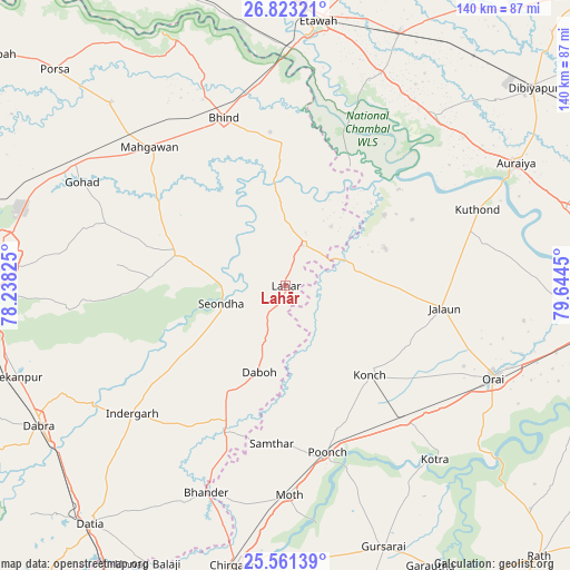
Lahār GPS coordinates[2]
26° 11' 38.436" North, 78° 56' 28.932" East
| Map corner | latitude | longitude |
|---|---|---|
| Upper-left | 26.82321°, | 78.23825° |
| Center: | 26.19401°, | 78.94137° |
| Lower-right: | 25.56139°, | 79.6445° |
| Map W x H: | 140.3×140.3 km | = 87.2×87.2mi |
| max Lat: | 34.9274° ⇑28.1% North |
| Lahār: | 26.19401° |
| min Lat: | ⇓71.9% South 8.09008° |
| min Long | Lahār | max Long |
| 68.82655° | 78.94137° | 96.81° |
| W 58.5%⇐ | ⇒41.5% E |
Elevation
Elevation of Lahār is 158 m = 518 ft, and this is 137.6 m = 451 ft below average elevation for this country.
| Max E: |
3681 m = 12077 ft | 58% |
| Avg. | 295.6 m = 970 ft | |
| Lahār | 158 m = 518 ft | |
Min E: |
1 m = 3 ft | 42% |
See also: India elevation on elevation.city.
Geographical zone
Lahār is located in North temperate zone (between Tropic of Cancer and the Arctic Circle). Distance of this Northern Tropic circle is 306.6 km =190.5 mi to South.| Distance of | km | miles | from Lahār |
|---|---|---|---|
| North Pole | 7094.6 | 4408.4 | to North |
| Arctic Circle | 4488.7 | 2789.1 | to North |
| Tropic Cancer | 306.6 | 190.5 | to South |
| Equator | 2912.5 | 1809.7 | to South |


Nearby cities:
15 places around Lahār: (largest is in red/bold)
• Alampur
23.7 km =14.7 mi,  217°
217°
• Bhind
44.2 km =27.5 mi,  339°
339°
• Daboh
22.3 km =13.9 mi,  196°
196°
• Jālaun
39.8 km =24.7 mi,  97°
97°
• Konch
30.5 km =19 mi,  136°
136°
• Mahgawān
46.6 km =29 mi,  315°
315°
• Mau
28.1 km =17.5 mi,  286°
286°
• Mihona
10.7 km =6.6 mi,  21°
21°
• Moth
52.1 km =32.4 mi,  179°
179°
• Mādhogarh
26 km =16.2 mi,  69°
69°
• Nadīgaon
12.6 km =7.8 mi, 139°
• Rāmpura
29.6 km =18.4 mi,  54°
54°
• Samthar
39.1 km =24.3 mi,  185°
185°
• Seondha
16.6 km =10.3 mi,  254°
254°
• Umri
35.2 km =21.9 mi,  359°
359°
Sources, notices
• [Note1] Compared only with cities in India existing in our database
• [Src1] Map data: © OpenStreetMap contributors (CC-BY-SA)
• [Src2] Other city data from geonames.org with taken over terms of usage.
• [Src3] Geographical zone / Annual Mean Temperature by Robert A. Rohde @ Wikipedia
