Dumka geodata
Dumka (Jharkhand) is a populated place; located in India in Asia/Kolkata (GMT+5.5) time zone. With population of 47,663 people, there are 923 cities with bigger population in this country. Compared to other cities in India, 59.4% of cities are located further ↓South; 89.7% of cities are located further ←West and 59.6% of cities have higher elevation than Dumka. Note1


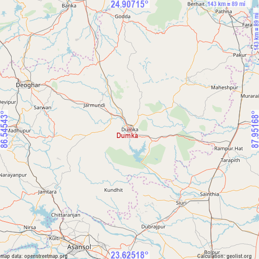
Dumka GPS coordinates[2]
24° 16' 4.008" North, 87° 14' 54.78" East
| Map corner | latitude | longitude |
|---|---|---|
| Upper-left | 24.90715°, | 86.54543° |
| Center: | 24.26778°, | 87.24855° |
| Lower-right: | 23.62518°, | 87.95168° |
| Map W x H: | 142.5×142.5 km | = 88.5×88.5mi |
| max Lat: | 34.9274° ⇑40.6% North |
| Dumka: | 24.26778° |
| min Lat: | ⇓59.4% South 8.09008° |
| min Long | Dumka | max Long |
| 68.82655° | 87.24855° | 96.81° |
| W 89.7%⇐ | ⇒10.3% E |
Elevation
Elevation of Dumka is 150 m = 492 ft, and this is 145.6 m = 478 ft below average elevation for this country.
| Max E: |
3681 m = 12077 ft | 59.6% |
| Avg. | 295.6 m = 970 ft | |
| Dumka | 150 m = 492 ft | |
Min E: |
1 m = 3 ft | 40.4% |
See also: Dumka elevation on elevation.city.
Geographical zone
Dumka is located in North temperate zone (between Tropic of Cancer and the Arctic Circle). Distance of this Northern Tropic circle is 92.4 km =57.4 mi to South.| Distance of | km | miles | from Dumka |
|---|---|---|---|
| North Pole | 7308.7 | 4541.4 | to North |
| Arctic Circle | 4702.8 | 2922.2 | to North |
| Tropic Cancer | 92.4 | 57.4 | to South |
| Equator | 2698.3 | 1676.6 | to South |


Nearby cities:
15 places around Dumka: (largest is in red/bold)
• Ahmadpur
65.9 km =40.9 mi,  137°
137°
• Bahula
69 km =42.9 mi,  187°
187°
• Bakreswar
44.6 km =27.7 mi,  163°
163°
• Chittaranjan
57.6 km =35.8 mi,  217°
217°
• Dubrājpur
54.7 km =34 mi,  166°
166°
• Godda
62.3 km =38.7 mi,  356°
356°
• Jasidih
66.9 km =41.6 mi,  294°
294°
• Jāmtāra
56.5 km =35.1 mi,  233°
233°
• Jāmuria
64.9 km =40.3 mi,  195°
195°
• Madhupur
61.8 km =38.4 mi,  270°
270°
• Nalhāti
58.9 km =36.6 mi,  86°
86°
• Rampur Hat
55.1 km =34.2 mi,  100°
100°
• Sainthia
56.4 km =35 mi,  129°
129°
• Siuri
49 km =30.4 mi, 144°
• Āsansol
70.3 km =43.7 mi, 202°
Sources, notices
• [Note1] Compared only with cities in India existing in our database
• [Src1] Map data: © OpenStreetMap contributors (CC-BY-SA)
• [Src2] Other city data from geonames.org with taken over terms of usage.
• [Src3] Geographical zone / Annual Mean Temperature by Robert A. Rohde @ Wikipedia
