Bilhaur geodata
Bilhaur (Uttar Pradesh) is a populated place; located in India in Asia/Kolkata (GMT+5.5) time zone. With population of 19,333 people, there are 2096 cities with bigger population in this country. Compared to other cities in India, 77.2% of cities are located further ↓South; 68.3% of cities are located further ←West and 62.1% of cities have higher elevation than Bilhaur. Note1


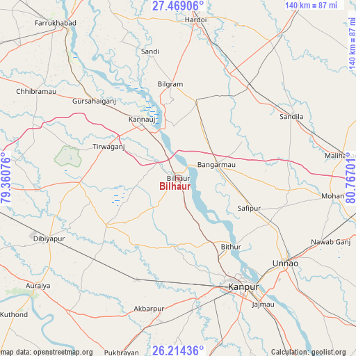
Bilhaur GPS coordinates[2]
26° 50' 36.42" North, 80° 3' 49.968" East
| Map corner | latitude | longitude |
|---|---|---|
| Upper-left | 27.46906°, | 79.36076° |
| Center: | 26.84345°, | 80.06388° |
| Lower-right: | 26.21436°, | 80.76701° |
| Map W x H: | 139.5×139.5 km | = 86.7×86.7mi |
| max Lat: | 34.9274° ⇑22.8% North |
| Bilhaur: | 26.84345° |
| min Lat: | ⇓77.2% South 8.09008° |
| min Long | Bilhaur | max Long |
| 68.82655° | 80.06388° | 96.81° |
| W 68.3%⇐ | ⇒31.7% E |
Elevation
Elevation of Bilhaur is 137 m = 449 ft, and this is 158.6 m = 520 ft below average elevation for this country.
| Max E: |
3681 m = 12077 ft | 62.1% |
| Avg. | 295.6 m = 970 ft | |
| Bilhaur | 137 m = 449 ft | |
Min E: |
1 m = 3 ft | 37.9% |
See also: India elevation on elevation.city.
Geographical zone
Bilhaur is located in North temperate zone (between Tropic of Cancer and the Arctic Circle). Distance of this Northern Tropic circle is 378.8 km =235.4 mi to South.| Distance of | km | miles | from Bilhaur |
|---|---|---|---|
| North Pole | 7022.4 | 4363.5 | to North |
| Arctic Circle | 4416.5 | 2744.3 | to North |
| Tropic Cancer | 378.8 | 235.4 | to South |
| Equator | 2984.7 | 1854.6 | to South |


Nearby cities:
15 places around Bilhaur: (largest is in red/bold)
• Aurās
44.7 km =27.8 mi,  79°
79°
• Bilgrām
37 km =23 mi,  355°
355°
• Bithūr
33.4 km =20.8 mi,  142°
142°
• Bāngarmau
15.6 km =9.7 mi,  70°
70°
• Fatehpur Chaurāsi
20.9 km =13 mi,  106°
106°
• Ganj Murādābād
17.4 km =10.8 mi,  43°
43°
• Gursahāiganj
44.7 km =27.8 mi,  312°
312°
• Indergarh
40.3 km =25 mi,  284°
284°
• Jhīnjhak
45.4 km =28.2 mi,  226°
226°
• Kannauj
27.6 km =17.1 mi,  328°
328°
• Mādhoganj
31.5 km =19.6 mi,  13°
13°
• Rasūlābād
43.7 km =27.2 mi,  104°
104°
• Rura
42.5 km =26.4 mi,  202°
202°
• Safīpur
30.1 km =18.7 mi, 112°
• Ugu
26 km =16.2 mi, 101°
Sources, notices
• [Note1] Compared only with cities in India existing in our database
• [Src1] Map data: © OpenStreetMap contributors (CC-BY-SA)
• [Src2] Other city data from geonames.org with taken over terms of usage.
• [Src3] Geographical zone / Annual Mean Temperature by Robert A. Rohde @ Wikipedia
