Hātā geodata
Hātā (Uttar Pradesh) is a populated place; located in India in Asia/Kolkata (GMT+5.5) time zone. With population of 12,050 people, there are 2733 cities with bigger population in this country. Compared to other cities in India, 76.3% of cities are located further ↓South; 81.3% of cities are located further ←West and 72.2% of cities have higher elevation than Hātā. Note1


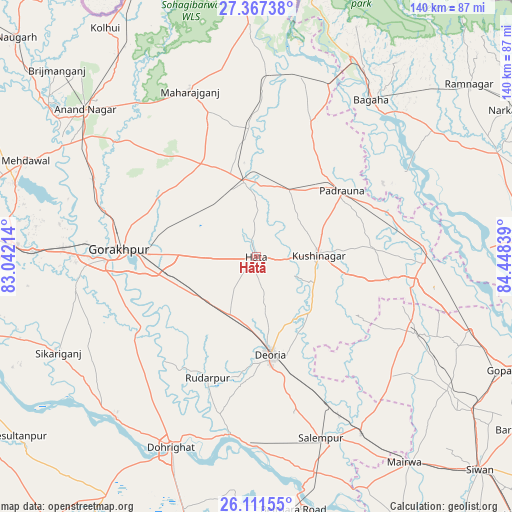
Hātā GPS coordinates[2]
26° 44' 28.32" North, 83° 44' 42.936" East
| Map corner | latitude | longitude |
|---|---|---|
| Upper-left | 27.36738°, | 83.04214° |
| Center: | 26.7412°, | 83.74526° |
| Lower-right: | 26.11155°, | 84.44839° |
| Map W x H: | 139.6×139.6 km | = 86.7×86.7mi |
| max Lat: | 34.9274° ⇑23.7% North |
| Hātā: | 26.7412° |
| min Lat: | ⇓76.3% South 8.09008° |
| min Long | Hātā | max Long |
| 68.82655° | 83.74526° | 96.81° |
| W 81.3%⇐ | ⇒18.7% E |
Elevation
Elevation of Hātā is 83 m = 272 ft, and this is 212.6 m = 698 ft below average elevation for this country.
| Max E: |
3681 m = 12077 ft | 72.2% |
| Avg. | 295.6 m = 970 ft | |
| Hātā | 83 m = 272 ft | |
Min E: |
1 m = 3 ft | 27.8% |
See also: India elevation on elevation.city.
Geographical zone
Hātā is located in North temperate zone (between Tropic of Cancer and the Arctic Circle). Distance of this Northern Tropic circle is 367.4 km =228.3 mi to South.| Distance of | km | miles | from Hātā |
|---|---|---|---|
| North Pole | 7033.7 | 4370.5 | to North |
| Arctic Circle | 4427.8 | 2751.3 | to North |
| Tropic Cancer | 367.4 | 228.3 | to South |
| Equator | 2973.3 | 1847.5 | to South |


Nearby cities:
15 places around Hātā: (largest is in red/bold)
• Bagaha
52.5 km =32.6 mi,  40°
40°
• Bānsgāon
45.1 km =28 mi,  241°
241°
• Captainganj
20.8 km =12.9 mi,  351°
351°
• Chillupār
56.3 km =35 mi,  204°
204°
• Deoria
26.8 km =16.7 mi,  172°
172°
• Dohrighāt
57.2 km =35.5 mi, 204°
• Gola Bāzār
58.9 km =36.6 mi,  221°
221°
• Gorakhpur
37.5 km =23.3 mi,  274°
274°
• Khada
51 km =31.7 mi,  15°
15°
• Mahārāganj
48.4 km =30.1 mi,  337°
337°
• Padrauna
29.6 km =18.4 mi,  52°
52°
• Pipraich
23.8 km =14.8 mi,  293°
293°
• Rāmkola
20.1 km =12.5 mi,  27°
27°
• Rūdarpur
35.5 km =22.1 mi, 201°
• Siswā Bāzār
45.1 km =28 mi,  1°
1°
Sources, notices
• [Note1] Compared only with cities in India existing in our database
• [Src1] Map data: © OpenStreetMap contributors (CC-BY-SA)
• [Src2] Other city data from geonames.org with taken over terms of usage.
• [Src3] Geographical zone / Annual Mean Temperature by Robert A. Rohde @ Wikipedia
