Gorakhpur geodata
Gorakhpur (Uttar Pradesh) is a populated place; located in India in Asia/Kolkata (GMT+5.5) time zone. With population of 674,246 people, there are 67 cities with bigger population in this country. Compared to other cities in India, 76.6% of cities are located further ↓South; 80.5% of cities are located further ←West and 72.2% of cities have higher elevation than Gorakhpur. Note1


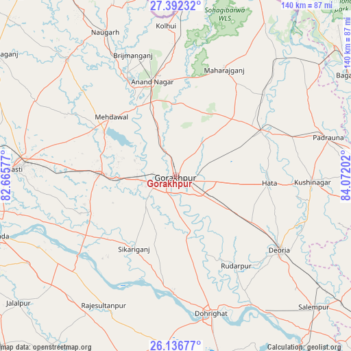
Gorakhpur GPS coordinates[2]
26° 45' 58.608" North, 83° 22' 8.004" East
| Map corner | latitude | longitude |
|---|---|---|
| Upper-left | 27.39232°, | 82.66577° |
| Center: | 26.76628°, | 83.36889° |
| Lower-right: | 26.13677°, | 84.07202° |
| Map W x H: | 139.6×139.6 km | = 86.7×86.7mi |
| max Lat: | 34.9274° ⇑23.4% North |
| Gorakhpur: | 26.76628° |
| min Lat: | ⇓76.6% South 8.09008° |
| min Long | Gorakhpur | max Long |
| 68.82655° | 83.36889° | 96.81° |
| W 80.5%⇐ | ⇒19.5% E |
Elevation
Elevation of Gorakhpur is 83 m = 272 ft, and this is 212.6 m = 698 ft below average elevation for this country.
| Max E: |
3681 m = 12077 ft | 72.2% |
| Avg. | 295.6 m = 970 ft | |
| Gorakhpur | 83 m = 272 ft | |
Min E: |
1 m = 3 ft | 27.8% |
See also: Gorakhpur elevation on elevation.city.
Geographical zone
Gorakhpur is located in North temperate zone (between Tropic of Cancer and the Arctic Circle). Distance of this Northern Tropic circle is 370.2 km =230 mi to South.| Distance of | km | miles | from Gorakhpur |
|---|---|---|---|
| North Pole | 7030.9 | 4368.8 | to North |
| Arctic Circle | 4425 | 2749.6 | to North |
| Tropic Cancer | 370.2 | 230 | to South |
| Equator | 2976.1 | 1849.3 | to South |


Nearby cities:
15 places around Gorakhpur: (largest is in red/bold)
• Anandnagar
38.4 km =23.9 mi,  345°
345°
• Bānsgāon
24.1 km =15 mi,  185°
185°
• Captainganj
38.5 km =23.9 mi,  62°
62°
• Chillupār
55.5 km =34.5 mi,  165°
165°
• Deoria
50.3 km =31.3 mi,  125°
125°
• Dohrighāt
56.7 km =35.2 mi, 165°
• Gola Bāzār
46.9 km =29.1 mi,  181°
181°
• Hātā
37.5 km =23.3 mi,  94°
94°
• Khalīlābād
29.5 km =18.3 mi,  271°
271°
• Maghar
24 km =14.9 mi, 267°
• Mahārāganj
46.2 km =28.7 mi,  24°
24°
• Mehndāwal
34.7 km =21.6 mi,  312°
312°
• Pipraich
17 km =10.6 mi,  66°
66°
• Rāmkola
48.9 km =30.4 mi, 72°
• Rūdarpur
43.2 km =26.8 mi,  145°
145°
Sources, notices
• [Note1] Compared only with cities in India existing in our database
• [Src1] Map data: © OpenStreetMap contributors (CC-BY-SA)
• [Src2] Other city data from geonames.org with taken over terms of usage.
• [Src3] Geographical zone / Annual Mean Temperature by Robert A. Rohde @ Wikipedia
