Kuchinda geodata
Kuchinda (Odisha) is a populated place; located in India in Asia/Kolkata (GMT+5.5) time zone. With population of 14,081 people, there are 2556 cities with bigger population in this country. Compared to other cities in India, 57.7% of cities are located further ↑North; 82.7% of cities are located further ←West and 58.6% of cities have lower elevation than Kuchinda. Note1


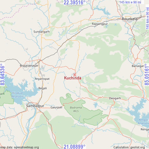
Kuchinda GPS coordinates[2]
21° 44' 36.816" North, 84° 20' 54.528" East
| Map corner | latitude | longitude |
|---|---|---|
| Upper-left | 22.39516°, | 83.64536° |
| Center: | 21.74356°, | 84.34848° |
| Lower-right: | 21.08899°, | 85.05161° |
| Map W x H: | 145.2×145.2 km | = 90.2×90.2mi |
| max Lat: | 34.9274° ⇑57.7% North |
| Kuchinda: | 21.74356° |
| min Lat: | ⇓42.3% South 8.09008° |
| min Long | Kuchinda | max Long |
| 68.82655° | 84.34848° | 96.81° |
| W 82.7%⇐ | ⇒17.3% E |
Elevation
Elevation of Kuchinda is 243 m = 797 ft, and this is 52.6 m = 173 ft below average elevation for this country.
| Max E: |
3681 m = 12077 ft | 41.4% |
| Avg. | 295.6 m = 970 ft | |
| Kuchinda | 243 m = 797 ft | |
Min E: |
1 m = 3 ft | 58.6% |
See also: India elevation on elevation.city.
Geographical zone
Kuchinda is located in North Torrid zone (between Equator and Tropic of Cancer). Distance of this Northern Tropic circle is 188.3 km =117 mi to North.| Distance of | km | miles | from Kuchinda |
|---|---|---|---|
| North Pole | 7589.4 | 4715.8 | to North |
| Arctic Circle | 4983.5 | 3096.6 | to North |
| Tropic Cancer | 188.3 | 117 | to North |
| Equator | 2417.7 | 1502.3 | to South |


Nearby cities:
15 places around Kuchinda: (largest is in red/bold)
• Bargarh
88.2 km =54.8 mi,  238°
238°
• Binka
97.2 km =60.4 mi,  214°
214°
• Birmitrapur
84.8 km =52.7 mi,  30°
30°
• Brājarājnagar
45.3 km =28.1 mi,  280°
280°
• Burla
55.6 km =34.5 mi, 242°
• Bānposh
73.6 km =45.7 mi,  40°
40°
• Deogarh
45.9 km =28.5 mi,  119°
119°
• Hīrākud
54.8 km =34.1 mi, 243°
• Jharsuguda
37.4 km =23.2 mi,  289°
289°
• Raigarh
99.7 km =62 mi, 279°
• Raurkela
75.4 km =46.9 mi, 44°
• Rengāli
32.4 km =20.1 mi,  250°
250°
• Sambalpur
49.4 km =30.7 mi,  231°
231°
• Simdega
98.2 km =61 mi,  9°
9°
• Sundargarh
52.7 km =32.7 mi,  321°
321°
Sources, notices
• [Note1] Compared only with cities in India existing in our database
• [Src1] Map data: © OpenStreetMap contributors (CC-BY-SA)
• [Src2] Other city data from geonames.org with taken over terms of usage.
• [Src3] Geographical zone / Annual Mean Temperature by Robert A. Rohde @ Wikipedia
