Simdega geodata
Simdega (Jharkhand) is a populated place; located in India in Asia/Kolkata (GMT+5.5) time zone. With population of 38,732 people, there are 1135 cities with bigger population in this country. Compared to other cities in India, 51.9% of cities are located further ↑North; 83.1% of cities are located further ←West and 78.8% of cities have lower elevation than Simdega. Note1


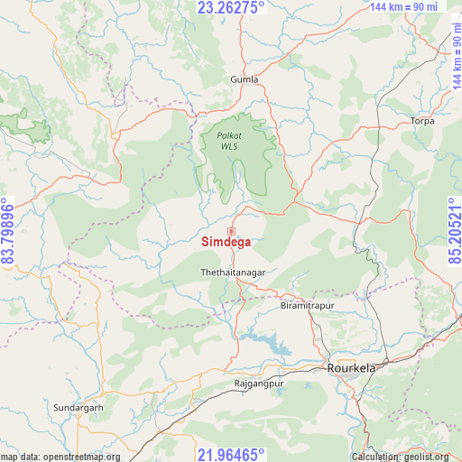
Simdega GPS coordinates[2]
22° 36' 54.828" North, 84° 30' 7.488" East
| Map corner | latitude | longitude |
|---|---|---|
| Upper-left | 23.26275°, | 83.79896° |
| Center: | 22.61523°, | 84.50208° |
| Lower-right: | 21.96465°, | 85.20521° |
| Map W x H: | 144.3×144.3 km | = 89.7×89.7mi |
| max Lat: | 34.9274° ⇑51.9% North |
| Simdega: | 22.61523° |
| min Lat: | ⇓48.1% South 8.09008° |
| min Long | Simdega | max Long |
| 68.82655° | 84.50208° | 96.81° |
| W 83.1%⇐ | ⇒16.9% E |
Elevation
Elevation of Simdega is 443 m = 1453 ft, and this is 147.4 m = 484 ft above average elevation for this country.
| Max E: |
3681 m = 12077 ft | 21.2% |
| Simdega | 443 m 1453 ft | |
| Avg. | 295.6 m = 970 ft | |
Min E: |
1 m = 3 ft | 78.8% |
See also: India elevation on elevation.city.
Geographical zone
Simdega is located in North Torrid zone (between Equator and Tropic of Cancer). Distance of this Northern Tropic circle is 91.3 km =56.7 mi to North.| Distance of | km | miles | from Simdega |
|---|---|---|---|
| North Pole | 7492.5 | 4655.6 | to North |
| Arctic Circle | 4886.6 | 3036.4 | to North |
| Tropic Cancer | 91.3 | 56.7 | to North |
| Equator | 2514.6 | 1562.5 | to South |


Nearby cities:
15 places around Simdega: (largest is in red/bold)
• Birmitrapur
36.2 km =22.5 mi,  131°
131°
• Bolānīkhodān
102.4 km =63.6 mi,  123°
123°
• Bānposh
51.7 km =32.1 mi,  142°
142°
• Chiria
86.4 km =53.7 mi,  113°
113°
• Gua
101.4 km =63 mi, 116°
• Gumlā
47.7 km =29.6 mi,  5°
5°
• Jashpurnagar
48 km =29.8 mi,  309°
309°
• Jharsuguda
98.7 km =61.3 mi,  211°
211°
• Khunti
94.6 km =58.8 mi,  57°
57°
• Kuchinda
98.2 km =61 mi,  189°
189°
• Lohārdagā
92.7 km =57.6 mi, 11°
• Manoharpur
75.8 km =47.1 mi, 110°
• Neturhāt
98.5 km =61.2 mi,  345°
345°
• Raurkela
57.2 km =35.5 mi, 139°
• Sundargarh
73.5 km =45.7 mi,  221°
221°
Sources, notices
• [Note1] Compared only with cities in India existing in our database
• [Src1] Map data: © OpenStreetMap contributors (CC-BY-SA)
• [Src2] Other city data from geonames.org with taken over terms of usage.
• [Src3] Geographical zone / Annual Mean Temperature by Robert A. Rohde @ Wikipedia
