Deogarh geodata
Deogarh (Odisha) is a populated place; located in India in Asia/Kolkata (GMT+5.5) time zone. With population of 21,134 people, there are 1958 cities with bigger population in this country. Compared to other cities in India, 58.8% of cities are located further ↑North; 83.6% of cities are located further ←West and 53.6% of cities have lower elevation than Deogarh. Note1


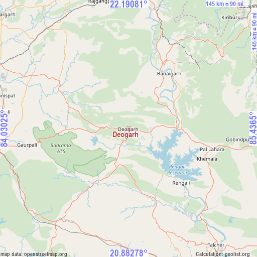
Deogarh GPS coordinates[2]
21° 32' 17.772" North, 84° 44' 0.132" East
| Map corner | latitude | longitude |
|---|---|---|
| Upper-left | 22.19081°, | 84.03025° |
| Center: | 21.53827°, | 84.73337° |
| Lower-right: | 20.88278°, | 85.4365° |
| Map W x H: | 145.4×145.4 km | = 90.3×90.3mi |
| max Lat: | 34.9274° ⇑58.8% North |
| Deogarh: | 21.53827° |
| min Lat: | ⇓41.2% South 8.09008° |
| min Long | Deogarh | max Long |
| 68.82655° | 84.73337° | 96.81° |
| W 83.6%⇐ | ⇒16.4% E |
Elevation
Elevation of Deogarh is 220 m = 722 ft, and this is 75.6 m = 248 ft below average elevation for this country.
| Max E: |
3681 m = 12077 ft | 46.4% |
| Avg. | 295.6 m = 970 ft | |
| Deogarh | 220 m = 722 ft | |
Min E: |
1 m = 3 ft | 53.6% |
See also: India elevation on elevation.city.
Geographical zone
Deogarh is located in North Torrid zone (between Equator and Tropic of Cancer). Distance of this Northern Tropic circle is 211.1 km =131.2 mi to North.| Distance of | km | miles | from Deogarh |
|---|---|---|---|
| North Pole | 7612.2 | 4730 | to North |
| Arctic Circle | 5006.3 | 3110.8 | to North |
| Tropic Cancer | 211.1 | 131.2 | to North |
| Equator | 2394.8 | 1488.1 | to South |


Nearby cities:
15 places around Deogarh: (largest is in red/bold)
• Angul
86.4 km =53.7 mi,  153°
153°
• Barbil
91.4 km =56.8 mi,  46°
46°
• Baud
88.6 km =55.1 mi,  208°
208°
• Bolānīkhodān
89.2 km =55.4 mi,  44°
44°
• Brājarājnagar
89.9 km =55.9 mi,  290°
290°
• Burla
89.1 km =55.4 mi,  267°
267°
• Bānposh
79.4 km =49.3 mi,  5°
5°
• Hīrākud
89 km =55.3 mi, 269°
• Jharsuguda
82.9 km =51.5 mi,  295°
295°
• Kiri Buru
87.9 km =54.6 mi, 46°
• Kuchinda
45.9 km =28.5 mi, 299°
• Raurkela
77.5 km =48.2 mi, 10°
• Rengāli
71.3 km =44.3 mi,  279°
279°
• Sambalpur
78.8 km =49 mi,  264°
264°
• Tālcher
83.5 km =51.9 mi,  141°
141°
Sources, notices
• [Note1] Compared only with cities in India existing in our database
• [Src1] Map data: © OpenStreetMap contributors (CC-BY-SA)
• [Src2] Other city data from geonames.org with taken over terms of usage.
• [Src3] Geographical zone / Annual Mean Temperature by Robert A. Rohde @ Wikipedia
