Rānikhet geodata
Rānikhet (Uttarakhand) is a populated place; located in India in Asia/Kolkata (GMT+5.5) time zone. With population of 19,873 people, there are 2051 cities with bigger population in this country. Compared to other cities in India, 91.7% of cities are located further ↓South; 63% of cities are located further ←West and 99% of cities have lower elevation than Rānikhet. Note1


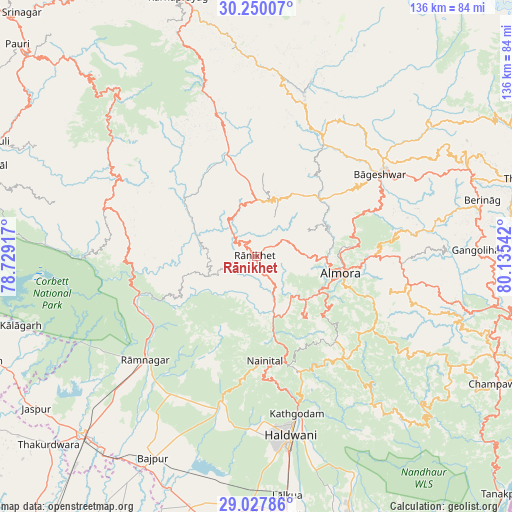
Rānikhet GPS coordinates[2]
29° 38' 26.952" North, 79° 25' 56.244" East
| Map corner | latitude | longitude |
|---|---|---|
| Upper-left | 30.25007°, | 78.72917° |
| Center: | 29.64082°, | 79.43229° |
| Lower-right: | 29.02786°, | 80.13542° |
| Map W x H: | 135.9×135.9 km | = 84.4×84.4mi |
| max Lat: | 34.9274° ⇑8.3% North |
| Rānikhet: | 29.64082° |
| min Lat: | ⇓91.7% South 8.09008° |
| min Long | Rānikhet | max Long |
| 68.82655° | 79.43229° | 96.81° |
| W 63%⇐ | ⇒37% E |
Elevation
Elevation of Rānikhet is 1804 m = 5919 ft, and this is 1508.4 m = 4949 ft above average elevation for this country.
| Max E: |
3681 m = 12077 ft | 1% |
| Rānikhet | 1804 m 5919 ft | |
| Avg. | 295.6 m = 970 ft | |
Min E: |
1 m = 3 ft | 99% |
See also: India elevation on elevation.city.
Geographical zone
Rānikhet is located in North temperate zone (between Tropic of Cancer and the Arctic Circle). Distance of this Northern Tropic circle is 689.8 km =428.6 mi to South.| Distance of | km | miles | from Rānikhet |
|---|---|---|---|
| North Pole | 6711.3 | 4170.2 | to North |
| Arctic Circle | 4105.4 | 2551 | to North |
| Tropic Cancer | 689.8 | 428.6 | to South |
| Equator | 3295.8 | 2047.9 | to South |


Nearby cities:
15 places around Rānikhet: (largest is in red/bold)
• Almora
22.5 km =14 mi,  102°
102°
• Bhowali
28.8 km =17.9 mi,  165°
165°
• Bhīm Tāl
35.3 km =21.9 mi,  158°
158°
• Bāgeshwar
39.4 km =24.5 mi,  56°
56°
• Bāzpur
62.7 km =39 mi,  210°
210°
• Champawat
71.1 km =44.2 mi,  118°
118°
• Dwārāhāt
15.2 km =9.4 mi,  358°
358°
• Haldwani
47.4 km =29.5 mi, 168°
• Jaspur
71 km =44.1 mi,  235°
235°
• Kashipur
66.1 km =41.1 mi,  224°
224°
• Kālādhūngi
40.5 km =25.2 mi,  191°
191°
• Kālāgarh Project Colony
65.2 km =40.5 mi,  253°
253°
• Lohaghāt
68.9 km =42.8 mi,  112°
112°
• Naini Tāl
27.1 km =16.8 mi,  177°
177°
• Rāmnagar
40.3 km =25 mi,  226°
226°
Sources, notices
• [Note1] Compared only with cities in India existing in our database
• [Src1] Map data: © OpenStreetMap contributors (CC-BY-SA)
• [Src2] Other city data from geonames.org with taken over terms of usage.
• [Src3] Geographical zone / Annual Mean Temperature by Robert A. Rohde @ Wikipedia
