Champawat geodata
Champawat (Uttarakhand) is a populated place; located in India in Asia/Kolkata (GMT+5.5) time zone. With population of 4,668 people, there are 3357 cities with bigger population in this country. Compared to other cities in India, 90.4% of cities are located further ↓South; 68.3% of cities are located further ←West and 98.4% of cities have lower elevation than Champawat. Note1


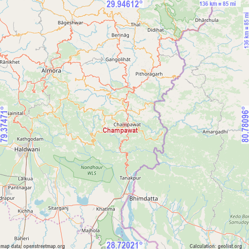
Champawat GPS coordinates[2]
29° 20' 6.036" North, 80° 4' 40.188" East
| Map corner | latitude | longitude |
|---|---|---|
| Upper-left | 29.94612°, | 79.37471° |
| Center: | 29.33501°, | 80.07783° |
| Lower-right: | 28.72021°, | 80.78096° |
| Map W x H: | 136.3×136.3 km | = 84.7×84.7mi |
| max Lat: | 34.9274° ⇑9.6% North |
| Champawat: | 29.33501° |
| min Lat: | ⇓90.4% South 8.09008° |
| min Long | Champawat | max Long |
| 68.82655° | 80.07783° | 96.81° |
| W 68.3%⇐ | ⇒31.7% E |
Elevation
Elevation of Champawat is 1626 m = 5335 ft, and this is 1330.4 m = 4365 ft above average elevation for this country.
| Max E: |
3681 m = 12077 ft | 1.6% |
| Champawat | 1626 m 5335 ft | |
| Avg. | 295.6 m = 970 ft | |
Min E: |
1 m = 3 ft | 98.4% |
See also: India elevation on elevation.city.
Geographical zone
Champawat is located in North temperate zone (between Tropic of Cancer and the Arctic Circle). Distance of this Northern Tropic circle is 655.8 km =407.5 mi to South.| Distance of | km | miles | from Champawat |
|---|---|---|---|
| North Pole | 6745.3 | 4191.3 | to North |
| Arctic Circle | 4139.4 | 2572.1 | to North |
| Tropic Cancer | 655.8 | 407.5 | to South |
| Equator | 3261.7 | 2026.7 | to South |


Nearby cities:
15 places around Champawat: (largest is in red/bold)
• Almora
49.9 km =31 mi,  305°
305°
• Banbasa
38.2 km =23.7 mi,  180°
180°
• Bhowali
55.9 km =34.7 mi,  276°
276°
• Bhīm Tāl
49.9 km =31 mi,  271°
271°
• Bāgeshwar
63.2 km =39.3 mi,  332°
332°
• Dhārchula
71.2 km =44.2 mi,  36°
36°
• Haldwani
54.7 km =34 mi,  256°
256°
• Khatīma
47.2 km =29.3 mi,  192°
192°
• Kālādhūngi
70.7 km =43.9 mi, 265°
• Lohaghāt
7.7 km =4.8 mi,  8°
8°
• Naini Tāl
61.5 km =38.2 mi, 276°
• Pithorāgarh
30.4 km =18.9 mi,  24°
24°
• Rānikhet
71.1 km =44.2 mi,  298°
298°
• Sitārganj
57.9 km =36 mi,  218°
218°
• Tanakpur
29.2 km =18.1 mi,  173°
173°
Sources, notices
• [Note1] Compared only with cities in India existing in our database
• [Src1] Map data: © OpenStreetMap contributors (CC-BY-SA)
• [Src2] Other city data from geonames.org with taken over terms of usage.
• [Src3] Geographical zone / Annual Mean Temperature by Robert A. Rohde @ Wikipedia
