Lohaghāt geodata
Lohaghāt (Uttarakhand) is a populated place; located in India in Asia/Kolkata (GMT+5.5) time zone. With population of 6,758 people, there are 3229 cities with bigger population in this country. Compared to other cities in India, 90.7% of cities are located further ↓South; 68.4% of cities are located further ←West and 98.8% of cities have lower elevation than Lohaghāt. Note1


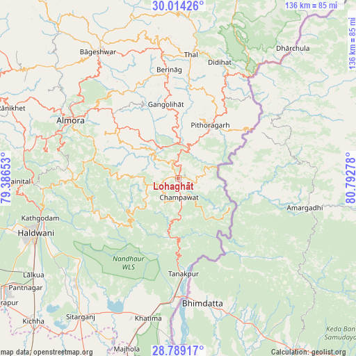
Lohaghāt GPS coordinates[2]
29° 24' 12.816" North, 80° 5' 22.74" East
| Map corner | latitude | longitude |
|---|---|---|
| Upper-left | 30.01426°, | 79.38653° |
| Center: | 29.40356°, | 80.08965° |
| Lower-right: | 28.78917°, | 80.79278° |
| Map W x H: | 136.2×136.2 km | = 84.6×84.6mi |
| max Lat: | 34.9274° ⇑9.3% North |
| Lohaghāt: | 29.40356° |
| min Lat: | ⇓90.7% South 8.09008° |
| min Long | Lohaghāt | max Long |
| 68.82655° | 80.08965° | 96.81° |
| W 68.4%⇐ | ⇒31.6% E |
Elevation
Elevation of Lohaghāt is 1701 m = 5581 ft, and this is 1405.4 m = 4611 ft above average elevation for this country.
| Max E: |
3681 m = 12077 ft | 1.2% |
| Lohaghāt | 1701 m 5581 ft | |
| Avg. | 295.6 m = 970 ft | |
Min E: |
1 m = 3 ft | 98.8% |
See also: India elevation on elevation.city.
Geographical zone
Lohaghāt is located in North temperate zone (between Tropic of Cancer and the Arctic Circle). Distance of this Northern Tropic circle is 663.5 km =412.3 mi to South.| Distance of | km | miles | from Lohaghāt |
|---|---|---|---|
| North Pole | 6737.7 | 4186.6 | to North |
| Arctic Circle | 4131.8 | 2567.4 | to North |
| Tropic Cancer | 663.5 | 412.3 | to South |
| Equator | 3269.4 | 2031.5 | to South |


Nearby cities:
15 places around Lohaghāt: (largest is in red/bold)
• Almora
46.9 km =29.1 mi,  297°
297°
• Banbasa
45.9 km =28.5 mi,  181°
181°
• Bhowali
56.7 km =35.2 mi,  268°
268°
• Bhīm Tāl
51.4 km =31.9 mi,  262°
262°
• Bāgeshwar
57.2 km =35.5 mi,  327°
327°
• Champawat
7.7 km =4.8 mi,  188°
188°
• Dhārchula
64.5 km =40.1 mi,  40°
40°
• Haldwani
58 km =36 mi,  249°
249°
• Khatīma
54.8 km =34.1 mi, 192°
• Kālādhūngi
72.8 km =45.2 mi, 259°
• Naini Tāl
62.3 km =38.7 mi, 269°
• Pithorāgarh
23.1 km =14.4 mi,  30°
30°
• Rānikhet
68.9 km =42.8 mi,  292°
292°
• Sitārganj
64.7 km =40.2 mi,  215°
215°
• Tanakpur
36.7 km =22.8 mi, 176°
Sources, notices
• [Note1] Compared only with cities in India existing in our database
• [Src1] Map data: © OpenStreetMap contributors (CC-BY-SA)
• [Src2] Other city data from geonames.org with taken over terms of usage.
• [Src3] Geographical zone / Annual Mean Temperature by Robert A. Rohde @ Wikipedia
