Rāmnagar geodata
Rāmnagar (Uttarakhand) is a populated place; located in India in Asia/Kolkata (GMT+5.5) time zone. With population of 51,244 people, there are 870 cities with bigger population in this country. Compared to other cities in India, 90.6% of cities are located further ↓South; 60.2% of cities are located further ←West and 73.3% of cities have lower elevation than Rāmnagar. Note1


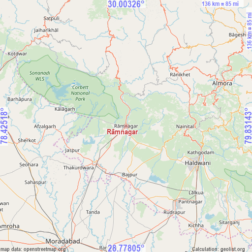
Rāmnagar GPS coordinates[2]
29° 23' 33" North, 79° 7' 41.88" East
| Map corner | latitude | longitude |
|---|---|---|
| Upper-left | 30.00326°, | 78.42518° |
| Center: | 29.3925°, | 79.1283° |
| Lower-right: | 28.77805°, | 79.83143° |
| Map W x H: | 136.2×136.2 km | = 84.6×84.6mi |
| max Lat: | 34.9274° ⇑9.4% North |
| Rāmnagar: | 29.3925° |
| min Lat: | ⇓90.6% South 8.09008° |
| min Long | Rāmnagar | max Long |
| 68.82655° | 79.1283° | 96.81° |
| W 60.2%⇐ | ⇒39.8% E |
Elevation
Elevation of Rāmnagar is 364 m = 1194 ft, and this is 68.4 m = 224 ft above average elevation for this country.
| Max E: |
3681 m = 12077 ft | 26.7% |
| Rāmnagar | 364 m 1194 ft | |
| Avg. | 295.6 m = 970 ft | |
Min E: |
1 m = 3 ft | 73.3% |
See also: Rāmnagar elevation on elevation.city.
Geographical zone
Rāmnagar is located in North temperate zone (between Tropic of Cancer and the Arctic Circle). Distance of this Northern Tropic circle is 662.2 km =411.5 mi to South.| Distance of | km | miles | from Rāmnagar |
|---|---|---|---|
| North Pole | 6738.9 | 4187.4 | to North |
| Arctic Circle | 4133 | 2568.1 | to North |
| Tropic Cancer | 662.2 | 411.5 | to South |
| Equator | 3268.1 | 2030.7 | to South |


Nearby cities:
15 places around Rāmnagar: (largest is in red/bold)
• Afzalgarh
44 km =27.3 mi,  270°
270°
• Bhowali
36.5 km =22.7 mi,  90°
90°
• Bhīm Tāl
42.5 km =26.4 mi,  97°
97°
• Bāzpur
26.7 km =16.6 mi,  184°
184°
• Dwārāhāt
51.7 km =32.1 mi,  34°
34°
• Haldwani
43.2 km =26.8 mi,  115°
115°
• Jaspur
31.7 km =19.7 mi,  246°
246°
• Kashipur
25.9 km =16.1 mi,  219°
219°
• Kālādhūngi
24.8 km =15.4 mi, 119°
• Kālāgarh Project Colony
34.6 km =21.5 mi,  285°
285°
• Naini Tāl
30.9 km =19.2 mi, 88°
• Rānikhet
40.3 km =25 mi,  46°
46°
• Suār
41.1 km =25.5 mi,  189°
189°
• Thakurdwara
34.2 km =21.3 mi,  229°
229°
• Tānda
49.7 km =30.9 mi,  201°
201°
Sources, notices
• [Note1] Compared only with cities in India existing in our database
• [Src1] Map data: © OpenStreetMap contributors (CC-BY-SA)
• [Src2] Other city data from geonames.org with taken over terms of usage.
• [Src3] Geographical zone / Annual Mean Temperature by Robert A. Rohde @ Wikipedia
