Haldwani geodata
Haldwani (Uttarakhand) is a populated place; located in India in Asia/Kolkata (GMT+5.5) time zone. With population of 139,497 people, there are 309 cities with bigger population in this country. Compared to other cities in India, 89.9% of cities are located further ↓South; 64.1% of cities are located further ←West and 79.2% of cities have lower elevation than Haldwani. Note1


Haldwani GPS coordinates[2]
29° 13' 21.144" North, 79° 31' 42.96" East
| Map corner | latitude | longitude |
|---|---|---|
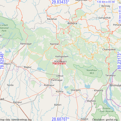
| Upper-left | 29.83433°, | 78.82548° |
| Center: | 29.22254°, | 79.5286° |
| Lower-right: | 28.60707°, | 80.23173° |
| Map W x H: | 136.5×136.5 km | = 84.8×84.8mi |
| max Lat: | 34.9274° ⇑10.1% North |
| Haldwani: | 29.22254° |
| min Lat: | ⇓89.9% South 8.09008° |
| min Long | Haldwani | max Long |
| 68.82655° | 79.5286° | 96.81° |
| W 64.1%⇐ | ⇒35.9% E |
Elevation
Elevation of Haldwani is 447 m = 1467 ft, and this is 151.4 m = 497 ft above average elevation for this country.
| Max E: |
3681 m = 12077 ft | 20.8% |
| Haldwani | 447 m 1467 ft | |
| Avg. | 295.6 m = 970 ft | |
Min E: |
1 m = 3 ft | 79.2% |
See also: Haldwani elevation on elevation.city.
Geographical zone
Haldwani is located in North temperate zone (between Tropic of Cancer and the Arctic Circle). Distance of this Northern Tropic circle is 643.3 km =399.7 mi to South.| Distance of | km | miles | from Haldwani |
|---|---|---|---|
| North Pole | 6757.8 | 4199.1 | to North |
| Arctic Circle | 4151.9 | 2579.9 | to North |
| Tropic Cancer | 643.3 | 399.7 | to South |
| Equator | 3249.2 | 2019 | to South |


Nearby cities:
15 places around Haldwani: (largest is in red/bold)
• Almora
43.5 km =27 mi,  16°
16°
• Baheri
49.9 km =31 mi,  183°
183°
• Bhowali
18.7 km =11.6 mi,  352°
352°
• Bhīm Tāl
14 km =8.7 mi,  13°
13°
• Bāzpur
41.5 km =25.8 mi,  259°
259°
• Bīlāspur
45 km =28 mi,  213°
213°
• Champawat
54.7 km =34 mi,  76°
76°
• Khatīma
54.5 km =33.9 mi,  127°
127°
• Kichha
34.6 km =21.5 mi, 181°
• Kālādhūngi
18.5 km =11.5 mi,  291°
291°
• Naini Tāl
21 km =13 mi,  337°
337°
• Rāmnagar
43.2 km =26.8 mi,  295°
295°
• Rānikhet
47.4 km =29.5 mi, 348°
• Sitārganj
36.8 km =22.9 mi,  152°
152°
• Suār
50.7 km =31.5 mi,  244°
244°
Sources, notices
• [Note1] Compared only with cities in India existing in our database
• [Src1] Map data: © OpenStreetMap contributors (CC-BY-SA)
• [Src2] Other city data from geonames.org with taken over terms of usage.
• [Src3] Geographical zone / Annual Mean Temperature by Robert A. Rohde @ Wikipedia
