Almora geodata
Almora (Uttarakhand) is a populated place; located in India in Asia/Kolkata (GMT+5.5) time zone. With population of 32,442 people, there are 1342 cities with bigger population in this country. Compared to other cities in India, 91.5% of cities are located further ↓South; 65.3% of cities are located further ←West and 98.3% of cities have lower elevation than Almora. Note1


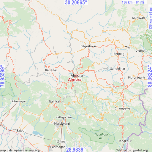
Almora GPS coordinates[2]
29° 35' 49.668" North, 79° 39' 32.796" East
| Map corner | latitude | longitude |
|---|---|---|
| Upper-left | 30.20665°, | 78.95599° |
| Center: | 29.59713°, | 79.65911° |
| Lower-right: | 28.9839°, | 80.36224° |
| Map W x H: | 136×136 km | = 84.5×84.5mi |
| max Lat: | 34.9274° ⇑8.5% North |
| Almora: | 29.59713° |
| min Lat: | ⇓91.5% South 8.09008° |
| min Long | Almora | max Long |
| 68.82655° | 79.65911° | 96.81° |
| W 65.3%⇐ | ⇒34.7% E |
Elevation
Elevation of Almora is 1600 m = 5249 ft, and this is 1304.4 m = 4280 ft above average elevation for this country.
| Max E: |
3681 m = 12077 ft | 1.7% |
| Almora | 1600 m 5249 ft | |
| Avg. | 295.6 m = 970 ft | |
Min E: |
1 m = 3 ft | 98.3% |
See also: India elevation on elevation.city.
Geographical zone
Almora is located in North temperate zone (between Tropic of Cancer and the Arctic Circle). Distance of this Northern Tropic circle is 685 km =425.6 mi to South.| Distance of | km | miles | from Almora |
|---|---|---|---|
| North Pole | 6716.2 | 4173.3 | to North |
| Arctic Circle | 4110.3 | 2554 | to North |
| Tropic Cancer | 685 | 425.6 | to South |
| Equator | 3290.9 | 2044.9 | to South |


Nearby cities:
15 places around Almora: (largest is in red/bold)
• Bhowali
27.5 km =17.1 mi,  212°
212°
• Bhīm Tāl
29.6 km =18.4 mi,  198°
198°
• Bāgeshwar
28.8 km =17.9 mi,  22°
22°
• Bāzpur
72.7 km =45.2 mi,  227°
227°
• Champawat
49.9 km =31 mi,  125°
125°
• Dwārāhāt
30.1 km =18.7 mi,  311°
311°
• Haldwani
43.5 km =27 mi, 196°
• Kālādhūngi
45.9 km =28.5 mi,  220°
220°
• Lohaghāt
46.9 km =29.1 mi,  117°
117°
• Naini Tāl
30.2 km =18.8 mi, 222°
• Pithorāgarh
53.2 km =33.1 mi,  91°
91°
• Rāmnagar
56.2 km =34.9 mi,  246°
246°
• Rānikhet
22.5 km =14 mi,  282°
282°
• Sitārganj
74.4 km =46.2 mi,  176°
176°
• Tanakpur
72.8 km =45.2 mi,  142°
142°
Sources, notices
• [Note1] Compared only with cities in India existing in our database
• [Src1] Map data: © OpenStreetMap contributors (CC-BY-SA)
• [Src2] Other city data from geonames.org with taken over terms of usage.
• [Src3] Geographical zone / Annual Mean Temperature by Robert A. Rohde @ Wikipedia
