Bhīm Tāl geodata
Bhīm Tāl (Uttarakhand) is a populated place; located in India in Asia/Kolkata (GMT+5.5) time zone. With population of 6,625 people, there are 3239 cities with bigger population in this country. Compared to other cities in India, 90.5% of cities are located further ↓South; 64.4% of cities are located further ←West and 97.3% of cities have lower elevation than Bhīm Tāl. Note1


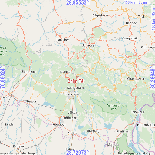
Bhīm Tāl GPS coordinates[2]
29° 20' 40.092" North, 79° 33' 48.096" East
| Map corner | latitude | longitude |
|---|---|---|
| Upper-left | 29.95553°, | 78.86024° |
| Center: | 29.34447°, | 79.56336° |
| Lower-right: | 28.72973°, | 80.26649° |
| Map W x H: | 136.3×136.3 km | = 84.7×84.7mi |
| max Lat: | 34.9274° ⇑9.5% North |
| Bhīm Tāl: | 29.34447° |
| min Lat: | ⇓90.5% South 8.09008° |
| min Long | Bhīm Tāl | max Long |
| 68.82655° | 79.56336° | 96.81° |
| W 64.4%⇐ | ⇒35.6% E |
Elevation
Elevation of Bhīm Tāl is 1343 m = 4406 ft, and this is 1047.4 m = 3436 ft above average elevation for this country.
| Max E: |
3681 m = 12077 ft | 2.7% |
| Bhīm Tāl | 1343 m 4406 ft | |
| Avg. | 295.6 m = 970 ft | |
Min E: |
1 m = 3 ft | 97.3% |
See also: India elevation on elevation.city.
Geographical zone
Bhīm Tāl is located in North temperate zone (between Tropic of Cancer and the Arctic Circle). Distance of this Northern Tropic circle is 656.9 km =408.2 mi to South.| Distance of | km | miles | from Bhīm Tāl |
|---|---|---|---|
| North Pole | 6744.3 | 4190.7 | to North |
| Arctic Circle | 4138.4 | 2571.5 | to North |
| Tropic Cancer | 656.9 | 408.2 | to South |
| Equator | 3262.8 | 2027.4 | to South |


Nearby cities:
15 places around Bhīm Tāl: (largest is in red/bold)
• Almora
29.6 km =18.4 mi,  18°
18°
• Bhowali
7.6 km =4.7 mi,  311°
311°
• Bāgeshwar
58.4 km =36.3 mi, 20°
• Bāzpur
49 km =30.4 mi,  244°
244°
• Bīlāspur
58.3 km =36.2 mi,  209°
209°
• Champawat
49.9 km =31 mi,  91°
91°
• Dwārāhāt
50 km =31.1 mi,  344°
344°
• Haldwani
14 km =8.7 mi,  193°
193°
• Kichha
48.3 km =30 mi,  184°
184°
• Kālādhūngi
21.7 km =13.5 mi,  251°
251°
• Lohaghāt
51.4 km =31.9 mi,  82°
82°
• Naini Tāl
12.7 km =7.9 mi,  297°
297°
• Rāmnagar
42.5 km =26.4 mi,  277°
277°
• Rānikhet
35.3 km =21.9 mi, 338°
• Sitārganj
48.2 km =30 mi,  163°
163°
Sources, notices
• [Note1] Compared only with cities in India existing in our database
• [Src1] Map data: © OpenStreetMap contributors (CC-BY-SA)
• [Src2] Other city data from geonames.org with taken over terms of usage.
• [Src3] Geographical zone / Annual Mean Temperature by Robert A. Rohde @ Wikipedia
