Bāgeshwar geodata
Bāgeshwar (Uttarakhand) is a populated place; located in India in Asia/Kolkata (GMT+5.5) time zone. With population of 8,708 people, there are 3063 cities with bigger population in this country. Compared to other cities in India, 92.4% of cities are located further ↓South; 66.3% of cities are located further ←West and 95% of cities have lower elevation than Bāgeshwar. Note1


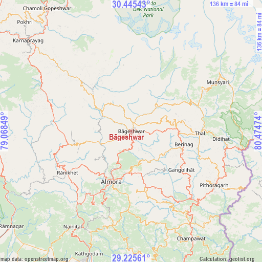
Bāgeshwar GPS coordinates[2]
29° 50' 14.568" North, 79° 46' 17.796" East
| Map corner | latitude | longitude |
|---|---|---|
| Upper-left | 30.44543°, | 79.06849° |
| Center: | 29.83738°, | 79.77161° |
| Lower-right: | 29.22561°, | 80.47474° |
| Map W x H: | 135.6×135.6 km | = 84.3×84.3mi |
| max Lat: | 34.9274° ⇑7.6% North |
| Bāgeshwar: | 29.83738° |
| min Lat: | ⇓92.4% South 8.09008° |
| min Long | Bāgeshwar | max Long |
| 68.82655° | 79.77161° | 96.81° |
| W 66.3%⇐ | ⇒33.7% E |
Elevation
Elevation of Bāgeshwar is 882 m = 2894 ft, and this is 586.4 m = 1924 ft above average elevation for this country.
| Max E: |
3681 m = 12077 ft | 5% |
| Bāgeshwar | 882 m 2894 ft | |
| Avg. | 295.6 m = 970 ft | |
Min E: |
1 m = 3 ft | 95% |
See also: India elevation on elevation.city.
Geographical zone
Bāgeshwar is located in North temperate zone (between Tropic of Cancer and the Arctic Circle). Distance of this Northern Tropic circle is 711.7 km =442.2 mi to South.| Distance of | km | miles | from Bāgeshwar |
|---|---|---|---|
| North Pole | 6689.5 | 4156.7 | to North |
| Arctic Circle | 4083.6 | 2537.4 | to North |
| Tropic Cancer | 711.7 | 442.2 | to South |
| Equator | 3317.6 | 2061.5 | to South |


Nearby cities:
15 places around Bāgeshwar: (largest is in red/bold)
• Almora
28.8 km =17.9 mi,  202°
202°
• Bhowali
56 km =34.8 mi,  207°
207°
• Bhīm Tāl
58.4 km =36.3 mi, 200°
• Champawat
63.2 km =39.3 mi,  152°
152°
• Dhārchula
72.1 km =44.8 mi,  89°
89°
• Dwārāhāt
33.9 km =21.1 mi,  258°
258°
• Haldwani
72.3 km =44.9 mi, 198°
• Joshīmath
82.3 km =51.1 mi,  345°
345°
• Kālādhūngi
73.8 km =45.9 mi, 213°
• Lohaghāt
57.2 km =35.5 mi, 147°
• Naini Tāl
58.1 km =36.1 mi, 212°
• Pithorāgarh
50.8 km =31.6 mi,  123°
123°
• Pīpalkoti
73.2 km =45.5 mi,  333°
333°
• Rāmnagar
79.5 km =49.4 mi,  231°
231°
• Rānikhet
39.4 km =24.5 mi,  236°
236°
Sources, notices
• [Note1] Compared only with cities in India existing in our database
• [Src1] Map data: © OpenStreetMap contributors (CC-BY-SA)
• [Src2] Other city data from geonames.org with taken over terms of usage.
• [Src3] Geographical zone / Annual Mean Temperature by Robert A. Rohde @ Wikipedia
