Rāmpur geodata
Rāmpur (Uttar Pradesh) is a populated place; located in India in Asia/Kolkata (GMT+5.5) time zone. With population of 296,418 people, there are 148 cities with bigger population in this country. Compared to other cities in India, 88.4% of cities are located further ↓South; 59.2% of cities are located further ←West and 51% of cities have higher elevation than Rāmpur. Note1


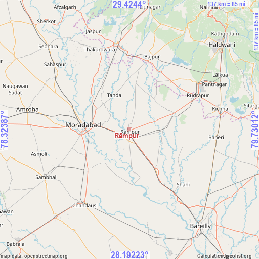
Rāmpur GPS coordinates[2]
28° 48' 36.504" North, 79° 1' 37.164" East
| Map corner | latitude | longitude |
|---|---|---|
| Upper-left | 29.4244°, | 78.32387° |
| Center: | 28.81014°, | 79.02699° |
| Lower-right: | 28.19223°, | 79.73012° |
| Map W x H: | 137×137 km | = 85.1×85.1mi |
| max Lat: | 34.9274° ⇑11.6% North |
| Rāmpur: | 28.81014° |
| min Lat: | ⇓88.4% South 8.09008° |
| min Long | Rāmpur | max Long |
| 68.82655° | 79.02699° | 96.81° |
| W 59.2%⇐ | ⇒40.8% E |
Elevation
Elevation of Rāmpur is 196 m = 643 ft, and this is 99.6 m = 327 ft below average elevation for this country.
| Max E: |
3681 m = 12077 ft | 51% |
| Avg. | 295.6 m = 970 ft | |
| Rāmpur | 196 m = 643 ft | |
Min E: |
1 m = 3 ft | 49% |
See also: Rāmpur elevation on elevation.city.
Geographical zone
Rāmpur is located in North temperate zone (between Tropic of Cancer and the Arctic Circle). Distance of this Northern Tropic circle is 597.5 km =371.3 mi to South.| Distance of | km | miles | from Rāmpur |
|---|---|---|---|
| North Pole | 6803.7 | 4227.6 | to North |
| Arctic Circle | 4197.8 | 2608.4 | to North |
| Tropic Cancer | 597.5 | 371.3 | to South |
| Equator | 3203.4 | 1990.5 | to South |


Nearby cities:
15 places around Rāmpur: (largest is in red/bold)
• Bilāri
30.2 km =18.8 mi,  226°
226°
• Bāzpur
38.9 km =24.2 mi,  11°
11°
• Bīlāspur
25.2 km =15.7 mi,  70°
70°
• Kemrī
17.3 km =10.7 mi,  91°
91°
• Kundarkhi
27.5 km =17.1 mi,  239°
239°
• Milak
26.2 km =16.3 mi,  147°
147°
• Morādābād
24.6 km =15.3 mi,  277°
277°
• Mīrganj
34.8 km =21.6 mi, 149°
• Sarauli
35.7 km =22.2 mi,  169°
169°
• Shergarh
37.7 km =23.4 mi,  117°
117°
• Shāhi
40.5 km =25.2 mi,  135°
135°
• Shāhābād
27.1 km =16.8 mi,  183°
183°
• Shīshgarh
29.4 km =18.3 mi,  107°
107°
• Suār
24.4 km =15.2 mi, 6°
• Tānda
20.2 km =12.6 mi,  335°
335°
Sources, notices
• [Note1] Compared only with cities in India existing in our database
• [Src1] Map data: © OpenStreetMap contributors (CC-BY-SA)
• [Src2] Other city data from geonames.org with taken over terms of usage.
• [Src3] Geographical zone / Annual Mean Temperature by Robert A. Rohde @ Wikipedia
