Tānda geodata
Tānda (Uttar Pradesh) is a populated place; located in India in Asia/Kolkata (GMT+5.5) time zone. With population of 44,822 people, there are 990 cities with bigger population in this country. Compared to other cities in India, 89% of cities are located further ↓South; 58.6% of cities are located further ←West and 51.1% of cities have lower elevation than Tānda. Note1


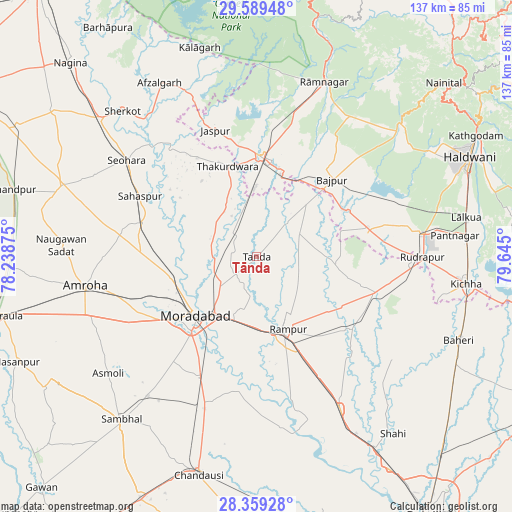
Tānda GPS coordinates[2]
28° 58' 34.356" North, 78° 56' 30.732" East
| Map corner | latitude | longitude |
|---|---|---|
| Upper-left | 29.58948°, | 78.23875° |
| Center: | 28.97621°, | 78.94187° |
| Lower-right: | 28.35928°, | 79.645° |
| Map W x H: | 136.8×136.8 km | = 85×85mi |
| max Lat: | 34.9274° ⇑11% North |
| Tānda: | 28.97621° |
| min Lat: | ⇓89% South 8.09008° |
| min Long | Tānda | max Long |
| 68.82655° | 78.94187° | 96.81° |
| W 58.6%⇐ | ⇒41.4% E |
Elevation
Elevation of Tānda is 208 m = 682 ft, and this is 87.6 m = 287 ft below average elevation for this country.
| Max E: |
3681 m = 12077 ft | 48.9% |
| Avg. | 295.6 m = 970 ft | |
| Tānda | 208 m = 682 ft | |
Min E: |
1 m = 3 ft | 51.1% |
See also: Tānda elevation on elevation.city.
Geographical zone
Tānda is located in North temperate zone (between Tropic of Cancer and the Arctic Circle). Distance of this Northern Tropic circle is 615.9 km =382.7 mi to South.| Distance of | km | miles | from Tānda |
|---|---|---|---|
| North Pole | 6785.2 | 4216.1 | to North |
| Arctic Circle | 4179.3 | 2596.9 | to North |
| Tropic Cancer | 615.9 | 382.7 | to South |
| Equator | 3221.9 | 2002 | to South |


Nearby cities:
15 places around Tānda: (largest is in red/bold)
• Bilāri
41.7 km =25.9 mi,  198°
198°
• Bāzpur
25.4 km =15.8 mi,  39°
39°
• Bīlāspur
33.5 km =20.8 mi,  107°
107°
• Jaspur
35.5 km =22.1 mi,  341°
341°
• Kashipur
26.5 km =16.5 mi,  3°
3°
• Kemrī
31.8 km =19.8 mi,  126°
126°
• Kundarkhi
36 km =22.4 mi,  205°
205°
• Kānth
31.7 km =19.7 mi,  286°
286°
• Morādābād
22.2 km =13.8 mi,  226°
226°
• Rāmpur
20.2 km =12.6 mi,  155°
155°
• Sahaspur
35 km =21.7 mi,  297°
297°
• Seohāra
43 km =26.7 mi,  307°
307°
• Shīshgarh
45.5 km =28.3 mi, 127°
• Suār
12.6 km =7.8 mi,  62°
62°
• Thakurdwara
25.2 km =15.7 mi, 341°
Sources, notices
• [Note1] Compared only with cities in India existing in our database
• [Src1] Map data: © OpenStreetMap contributors (CC-BY-SA)
• [Src2] Other city data from geonames.org with taken over terms of usage.
• [Src3] Geographical zone / Annual Mean Temperature by Robert A. Rohde @ Wikipedia
