Suār geodata
Suār (Uttar Pradesh) is a populated place; located in India in Asia/Kolkata (GMT+5.5) time zone. With population of 28,941 people, there are 1499 cities with bigger population in this country. Compared to other cities in India, 89.1% of cities are located further ↓South; 59.3% of cities are located further ←West and 51.6% of cities have lower elevation than Suār. Note1


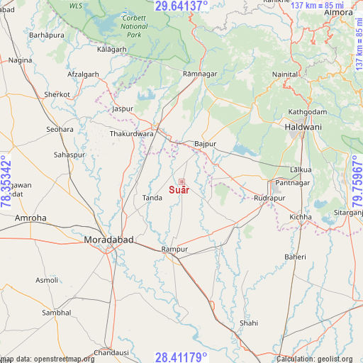
Suār GPS coordinates[2]
29° 1' 42.276" North, 79° 3' 23.544" East
| Map corner | latitude | longitude |
|---|---|---|
| Upper-left | 29.64137°, | 78.35342° |
| Center: | 29.02841°, | 79.05654° |
| Lower-right: | 28.41179°, | 79.75967° |
| Map W x H: | 136.7×136.7 km | = 84.9×84.9mi |
| max Lat: | 34.9274° ⇑10.9% North |
| Suār: | 29.02841° |
| min Lat: | ⇓89.1% South 8.09008° |
| min Long | Suār | max Long |
| 68.82655° | 79.05654° | 96.81° |
| W 59.3%⇐ | ⇒40.7% E |
Elevation
Elevation of Suār is 211 m = 692 ft, and this is 84.6 m = 278 ft below average elevation for this country.
| Max E: |
3681 m = 12077 ft | 48.4% |
| Avg. | 295.6 m = 970 ft | |
| Suār | 211 m = 692 ft | |
Min E: |
1 m = 3 ft | 51.6% |
See also: India elevation on elevation.city.
Geographical zone
Suār is located in North temperate zone (between Tropic of Cancer and the Arctic Circle). Distance of this Northern Tropic circle is 621.7 km =386.3 mi to South.| Distance of | km | miles | from Suār |
|---|---|---|---|
| North Pole | 6779.4 | 4212.5 | to North |
| Arctic Circle | 4173.5 | 2593.3 | to North |
| Tropic Cancer | 621.7 | 386.3 | to South |
| Equator | 3227.7 | 2005.6 | to South |


Nearby cities:
15 places around Suār: (largest is in red/bold)
• Bāzpur
14.7 km =9.1 mi,  19°
19°
• Bīlāspur
26.1 km =16.2 mi,  127°
127°
• Jaspur
35.6 km =22.1 mi,  321°
321°
• Kashipur
22.8 km =14.2 mi,  334°
334°
• Kemrī
28.6 km =17.8 mi,  149°
149°
• Kundarkhi
46.6 km =29 mi,  214°
214°
• Kālādhūngi
40.3 km =25 mi,  45°
45°
• Kānth
41.7 km =25.9 mi,  274°
274°
• Morādābād
34.4 km =21.4 mi,  232°
232°
• Rāmnagar
41.1 km =25.5 mi,  9°
9°
• Rāmpur
24.4 km =15.2 mi,  186°
186°
• Sahaspur
43.4 km =27 mi,  283°
283°
• Shīshgarh
41.7 km =25.9 mi,  142°
142°
• Thakurdwara
26.3 km =16.3 mi,  313°
313°
• Tānda
12.6 km =7.8 mi,  242°
242°
Sources, notices
• [Note1] Compared only with cities in India existing in our database
• [Src1] Map data: © OpenStreetMap contributors (CC-BY-SA)
• [Src2] Other city data from geonames.org with taken over terms of usage.
• [Src3] Geographical zone / Annual Mean Temperature by Robert A. Rohde @ Wikipedia
