Morādābād geodata
Morādābād (Uttar Pradesh) is a seat of a second-order administrative division; located in India in Asia/Kolkata (GMT+5.5) time zone. With population of 721,139 people, there are 64 cities with bigger population in this country. Compared to other cities in India, 88.5% of cities are located further ↓South; 56.5% of cities are located further ←West and 50.5% of cities have lower elevation than Morādābād. Note1


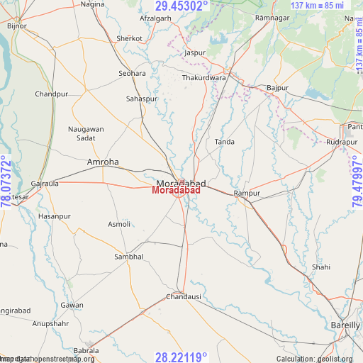
Morādābād GPS coordinates[2]
28° 50' 20.148" North, 78° 46' 36.624" East
| Map corner | latitude | longitude |
|---|---|---|
| Upper-left | 29.45302°, | 78.07372° |
| Center: | 28.83893°, | 78.77684° |
| Lower-right: | 28.22119°, | 79.47997° |
| Map W x H: | 137×137 km | = 85.1×85.1mi |
| max Lat: | 34.9274° ⇑11.5% North |
| Morādābād: | 28.83893° |
| min Lat: | ⇓88.5% South 8.09008° |
| min Long | Morādābād | max Long |
| 68.82655° | 78.77684° | 96.81° |
| W 56.5%⇐ | ⇒43.5% E |
Elevation
Elevation of Morādābād is 205 m = 673 ft, and this is 90.6 m = 297 ft below average elevation for this country.
| Max E: |
3681 m = 12077 ft | 49.5% |
| Avg. | 295.6 m = 970 ft | |
| Morādābād | 205 m = 673 ft | |
Min E: |
1 m = 3 ft | 50.5% |
See also: Morādābād elevation on elevation.city.
Geographical zone
Morādābād is located in North temperate zone (between Tropic of Cancer and the Arctic Circle). Distance of this Northern Tropic circle is 600.7 km =373.3 mi to South.| Distance of | km | miles | from Morādābād |
|---|---|---|---|
| North Pole | 6800.5 | 4225.6 | to North |
| Arctic Circle | 4194.6 | 2606.4 | to North |
| Tropic Cancer | 600.7 | 373.3 | to South |
| Equator | 3206.6 | 1992.5 | to South |


Nearby cities:
15 places around Morādābād: (largest is in red/bold)
• Amroha
30.7 km =19.1 mi,  283°
283°
• Bilāri
24.3 km =15.1 mi,  173°
173°
• Chanduasi
43.1 km =26.8 mi,  179°
179°
• Kemrī
41.8 km =26 mi,  94°
94°
• Kundarkhi
17.4 km =10.8 mi, 177°
• Kānth
28.4 km =17.6 mi,  329°
329°
• Narauli
39.8 km =24.7 mi,  188°
188°
• Rāmpur
24.6 km =15.3 mi,  97°
97°
• Sahaspur
34.8 km =21.6 mi, 334°
• Sambhal
34.7 km =21.6 mi,  215°
215°
• Shāhābād
37.8 km =23.5 mi,  143°
143°
• Sirsi
25.8 km =16 mi,  210°
210°
• Suār
34.4 km =21.4 mi,  52°
52°
• Thakurdwara
40.1 km =24.9 mi,  11°
11°
• Tānda
22.2 km =13.8 mi, 46°
Sources, notices
• [Note1] Compared only with cities in India existing in our database
• [Src1] Map data: © OpenStreetMap contributors (CC-BY-SA)
• [Src2] Other city data from geonames.org with taken over terms of usage.
• [Src3] Geographical zone / Annual Mean Temperature by Robert A. Rohde @ Wikipedia
