Kundarkhi geodata
Kundarkhi (Uttar Pradesh) is a populated place; located in India in Asia/Kolkata (GMT+5.5) time zone. With population of 27,197 people, there are 1577 cities with bigger population in this country. Compared to other cities in India, 87.7% of cities are located further ↓South; 56.8% of cities are located further ←West and 50.8% of cities have higher elevation than Kundarkhi. Note1


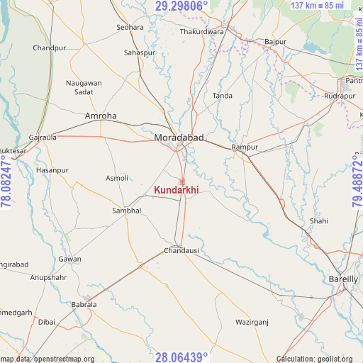
Kundarkhi GPS coordinates[2]
28° 40' 58.944" North, 78° 47' 8.124" East
| Map corner | latitude | longitude |
|---|---|---|
| Upper-left | 29.29806°, | 78.08247° |
| Center: | 28.68304°, | 78.78559° |
| Lower-right: | 28.06439°, | 79.48872° |
| Map W x H: | 137.2×137.2 km | = 85.3×85.3mi |
| max Lat: | 34.9274° ⇑12.3% North |
| Kundarkhi: | 28.68304° |
| min Lat: | ⇓87.7% South 8.09008° |
| min Long | Kundarkhi | max Long |
| 68.82655° | 78.78559° | 96.81° |
| W 56.8%⇐ | ⇒43.2% E |
Elevation
Elevation of Kundarkhi is 198 m = 650 ft, and this is 97.6 m = 320 ft below average elevation for this country.
| Max E: |
3681 m = 12077 ft | 50.8% |
| Avg. | 295.6 m = 970 ft | |
| Kundarkhi | 198 m = 650 ft | |
Min E: |
1 m = 3 ft | 49.2% |
See also: India elevation on elevation.city.
Geographical zone
Kundarkhi is located in North temperate zone (between Tropic of Cancer and the Arctic Circle). Distance of this Northern Tropic circle is 583.3 km =362.4 mi to South.| Distance of | km | miles | from Kundarkhi |
|---|---|---|---|
| North Pole | 6817.8 | 4236.4 | to North |
| Arctic Circle | 4211.9 | 2617.2 | to North |
| Tropic Cancer | 583.3 | 362.4 | to South |
| Equator | 3189.3 | 1981.7 | to South |


Nearby cities:
15 places around Kundarkhi: (largest is in red/bold)
• Amroha
39.3 km =24.4 mi,  308°
308°
• Bahjoi
35.6 km =22.1 mi,  205°
205°
• Bilāri
7.1 km =4.4 mi,  165°
165°
• Chanduasi
25.7 km =16 mi,  180°
180°
• Islāmnagar
39.8 km =24.7 mi,  188°
188°
• Kemrī
43.1 km =26.8 mi,  71°
71°
• Milak
38.4 km =23.9 mi,  102°
102°
• Morādābād
17.4 km =10.8 mi,  357°
357°
• Narauli
23 km =14.3 mi,  197°
197°
• Rāmpur
27.5 km =17.1 mi,  59°
59°
• Sambhal
23.7 km =14.7 mi,  242°
242°
• Sarauli
36.5 km =22.7 mi,  125°
125°
• Shāhābād
25.4 km =15.8 mi,  120°
120°
• Sirsi
14.7 km =9.1 mi,  250°
250°
• Tānda
36 km =22.4 mi,  25°
25°
Sources, notices
• [Note1] Compared only with cities in India existing in our database
• [Src1] Map data: © OpenStreetMap contributors (CC-BY-SA)
• [Src2] Other city data from geonames.org with taken over terms of usage.
• [Src3] Geographical zone / Annual Mean Temperature by Robert A. Rohde @ Wikipedia
