Rīngas geodata
Rīngas (Rajasthan) is a populated place; located in India in Asia/Kolkata (GMT+5.5) time zone. With population of 25,171 people, there are 1690 cities with bigger population in this country. Compared to other cities in India, 81% of cities are located further ↓South; 77.9% of cities are located further →East and 81.3% of cities have lower elevation than Rīngas. Note1


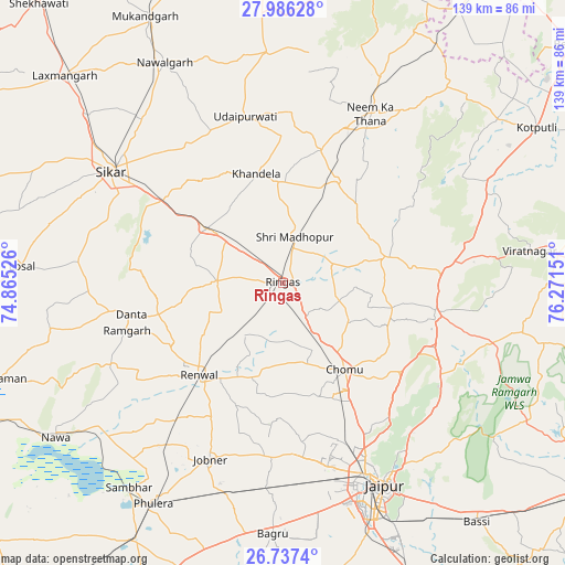
Rīngas GPS coordinates[2]
27° 21' 48.96" North, 75° 34' 6.168" East
| Map corner | latitude | longitude |
|---|---|---|
| Upper-left | 27.98628°, | 74.86526° |
| Center: | 27.3636°, | 75.56838° |
| Lower-right: | 26.7374°, | 76.27151° |
| Map W x H: | 138.9×138.9 km | = 86.3×86.3mi |
| max Lat: | 34.9274° ⇑19% North |
| Rīngas: | 27.3636° |
| min Lat: | ⇓81% South 8.09008° |
| min Long | Rīngas | max Long |
| 68.82655° | 75.56838° | 96.81° |
| W 22.1%⇐ | ⇒77.9% E |
Elevation
Elevation of Rīngas is 475 m = 1558 ft, and this is 179.4 m = 589 ft above average elevation for this country.
| Max E: |
3681 m = 12077 ft | 18.7% |
| Rīngas | 475 m 1558 ft | |
| Avg. | 295.6 m = 970 ft | |
Min E: |
1 m = 3 ft | 81.3% |
See also: India elevation on elevation.city.
Geographical zone
Rīngas is located in North temperate zone (between Tropic of Cancer and the Arctic Circle). Distance of this Northern Tropic circle is 436.6 km =271.3 mi to South.| Distance of | km | miles | from Rīngas |
|---|---|---|---|
| North Pole | 6964.5 | 4327.5 | to North |
| Arctic Circle | 4358.6 | 2708.3 | to North |
| Tropic Cancer | 436.6 | 271.3 | to South |
| Equator | 3042.5 | 1890.5 | to South |


Nearby cities:
15 places around Rīngas: (largest is in red/bold)
• Jaipur
53.9 km =33.5 mi,  156°
156°
• Jobner
47 km =29.2 mi,  202°
202°
• Khandela
27.6 km =17.1 mi,  346°
346°
• Losal
64.5 km =40.1 mi,  273°
273°
• Manoharpur
38.4 km =23.9 mi,  101°
101°
• Nawalgarh
61.5 km =38.2 mi,  331°
331°
• Neem ka Thana
47 km =29.2 mi,  27°
27°
• Nāwa
67.8 km =42.1 mi,  235°
235°
• Phulera
63.3 km =39.3 mi,  210°
210°
• Rāmgarh
40.5 km =25.2 mi,  251°
251°
• Shāhpura
38.7 km =24 mi,  85°
85°
• Sri Mādhopur
11.7 km =7.3 mi,  14°
14°
• Sāmbhar
62.9 km =39.1 mi,  216°
216°
• Sīkar
50.5 km =31.4 mi,  303°
303°
• Udaipur
41.1 km =25.5 mi, 346°
Sources, notices
• [Note1] Compared only with cities in India existing in our database
• [Src1] Map data: © OpenStreetMap contributors (CC-BY-SA)
• [Src2] Other city data from geonames.org with taken over terms of usage.
• [Src3] Geographical zone / Annual Mean Temperature by Robert A. Rohde @ Wikipedia
