Naraina geodata
Naraina (Rajasthan) is a populated place; located in India in Asia/Kolkata (GMT+5.5) time zone. With population of 17,048 people, there are 2281 cities with bigger population in this country. Compared to other cities in India, 76.8% of cities are located further ↓South; 80.9% of cities are located further →East and 74.6% of cities have lower elevation than Naraina. Note1


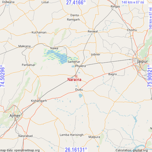
Naraina GPS coordinates[2]
26° 47' 26.484" North, 75° 12' 21.888" East
| Map corner | latitude | longitude |
|---|---|---|
| Upper-left | 27.4166°, | 74.50296° |
| Center: | 26.79069°, | 75.20608° |
| Lower-right: | 26.16131°, | 75.90921° |
| Map W x H: | 139.6×139.6 km | = 86.7×86.7mi |
| max Lat: | 34.9274° ⇑23.2% North |
| Naraina: | 26.79069° |
| min Lat: | ⇓76.8% South 8.09008° |
| min Long | Naraina | max Long |
| 68.82655° | 75.20608° | 96.81° |
| W 19.1%⇐ | ⇒80.9% E |
Elevation
Elevation of Naraina is 381 m = 1250 ft, and this is 85.4 m = 280 ft above average elevation for this country.
| Max E: |
3681 m = 12077 ft | 25.4% |
| Naraina | 381 m 1250 ft | |
| Avg. | 295.6 m = 970 ft | |
Min E: |
1 m = 3 ft | 74.6% |
See also: India elevation on elevation.city.
Geographical zone
Naraina is located in North temperate zone (between Tropic of Cancer and the Arctic Circle). Distance of this Northern Tropic circle is 372.9 km =231.7 mi to South.| Distance of | km | miles | from Naraina |
|---|---|---|---|
| North Pole | 7028.2 | 4367.1 | to North |
| Arctic Circle | 4422.3 | 2747.9 | to North |
| Tropic Cancer | 372.9 | 231.7 | to South |
| Equator | 2978.8 | 1850.9 | to South |


Nearby cities:
15 places around Naraina: (largest is in red/bold)
• Ajmer
67.8 km =42.1 mi,  236°
236°
• Jaipur
59.5 km =37 mi,  76°
76°
• Jobner
27.1 km =16.8 mi,  41°
41°
• Kishangarh
41.5 km =25.8 mi, 237°
• Kuchāman
52.7 km =32.7 mi,  318°
318°
• Makrāna
55.4 km =34.4 mi,  300°
300°
• Mālpura
58.5 km =36.4 mi,  164°
164°
• Nasīrābād
71.6 km =44.5 mi,  221°
221°
• Nāwa
32.5 km =20.2 mi, 321°
• Parvatsar
44.9 km =27.9 mi,  283°
283°
• Phulera
9.9 km =6.2 mi,  20°
20°
• Rāmgarh
51.2 km =31.8 mi,  356°
356°
• Rīngas
73.1 km =45.4 mi,  29°
29°
• Sāmbhar
13.1 km =8.1 mi,  353°
353°
• Uniāra
70.9 km =44.1 mi,  179°
179°
Sources, notices
• [Note1] Compared only with cities in India existing in our database
• [Src1] Map data: © OpenStreetMap contributors (CC-BY-SA)
• [Src2] Other city data from geonames.org with taken over terms of usage.
• [Src3] Geographical zone / Annual Mean Temperature by Robert A. Rohde @ Wikipedia
