Sri Mādhopur geodata
Sri Mādhopur (Rajasthan) is a populated place; located in India in Asia/Kolkata (GMT+5.5) time zone. With population of 30,281 people, there are 1430 cities with bigger population in this country. Compared to other cities in India, 81.5% of cities are located further ↓South; 77.6% of cities are located further →East and 82.6% of cities have lower elevation than Sri Mādhopur. Note1


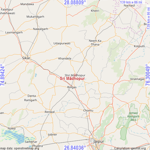
Sri Mādhopur GPS coordinates[2]
27° 27' 57.564" North, 75° 35' 50.496" East
| Map corner | latitude | longitude |
|---|---|---|
| Upper-left | 28.08809°, | 74.89424° |
| Center: | 27.46599°, | 75.59736° |
| Lower-right: | 26.84036°, | 76.30049° |
| Map W x H: | 138.7×138.7 km | = 86.2×86.2mi |
| max Lat: | 34.9274° ⇑18.5% North |
| Sri Mādhopur: | 27.46599° |
| min Lat: | ⇓81.5% South 8.09008° |
| min Long | Sri Mādhopur | max Long |
| 68.82655° | 75.59736° | 96.81° |
| W 22.4%⇐ | ⇒77.6% E |
Elevation
Elevation of Sri Mādhopur is 502 m = 1647 ft, and this is 206.4 m = 677 ft above average elevation for this country.
| Max E: |
3681 m = 12077 ft | 17.4% |
| Sri Mādhopur | 502 m 1647 ft | |
| Avg. | 295.6 m = 970 ft | |
Min E: |
1 m = 3 ft | 82.6% |
See also: India elevation on elevation.city.
Geographical zone
Sri Mādhopur is located in North temperate zone (between Tropic of Cancer and the Arctic Circle). Distance of this Northern Tropic circle is 448 km =278.4 mi to South.| Distance of | km | miles | from Sri Mādhopur |
|---|---|---|---|
| North Pole | 6953.1 | 4320.5 | to North |
| Arctic Circle | 4347.2 | 2701.2 | to North |
| Tropic Cancer | 448 | 278.4 | to South |
| Equator | 3053.9 | 1897.6 | to South |


Nearby cities:
15 places around Sri Mādhopur: (largest is in red/bold)
• Jaipur
63.6 km =39.5 mi,  162°
162°
• Jobner
58.7 km =36.5 mi,  200°
200°
• Khandela
18.1 km =11.2 mi,  328°
328°
• Khetri
62.3 km =38.7 mi,  17°
17°
• Kotputli
64.9 km =40.3 mi,  66°
66°
• Lachhmangarh Sīkar
68.7 km =42.7 mi,  305°
305°
• Losal
67.6 km =42 mi,  263°
263°
• Manoharpur
39.5 km =24.5 mi,  118°
118°
• Nawalgarh
53.4 km =33.2 mi,  323°
323°
• Neem ka Thana
35.7 km =22.2 mi,  31°
31°
• Rāmgarh
47.7 km =29.6 mi,  239°
239°
• Rīngas
11.7 km =7.3 mi,  194°
194°
• Shāhpura
36.7 km =22.8 mi,  103°
103°
• Sīkar
47.9 km =29.8 mi,  289°
289°
• Udaipur
31.1 km =19.3 mi,  336°
336°
Sources, notices
• [Note1] Compared only with cities in India existing in our database
• [Src1] Map data: © OpenStreetMap contributors (CC-BY-SA)
• [Src2] Other city data from geonames.org with taken over terms of usage.
• [Src3] Geographical zone / Annual Mean Temperature by Robert A. Rohde @ Wikipedia
