Jobner geodata
Jobner (Rajasthan) is a populated place; located in India in Asia/Kolkata (GMT+5.5) time zone. With population of 10,828 people, there are 2850 cities with bigger population in this country. Compared to other cities in India, 78.2% of cities are located further ↓South; 79.3% of cities are located further →East and 76% of cities have lower elevation than Jobner. Note1


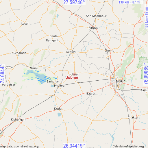
Jobner GPS coordinates[2]
26° 58' 21.252" North, 75° 23' 15.072" East
| Map corner | latitude | longitude |
|---|---|---|
| Upper-left | 27.59746°, | 74.6844° |
| Center: | 26.97257°, | 75.38752° |
| Lower-right: | 26.34419°, | 76.09065° |
| Map W x H: | 139.4×139.4 km | = 86.6×86.6mi |
| max Lat: | 34.9274° ⇑21.8% North |
| Jobner: | 26.97257° |
| min Lat: | ⇓78.2% South 8.09008° |
| min Long | Jobner | max Long |
| 68.82655° | 75.38752° | 96.81° |
| W 20.7%⇐ | ⇒79.3% E |
Elevation
Elevation of Jobner is 399 m = 1309 ft, and this is 103.4 m = 339 ft above average elevation for this country.
| Max E: |
3681 m = 12077 ft | 24% |
| Jobner | 399 m 1309 ft | |
| Avg. | 295.6 m = 970 ft | |
Min E: |
1 m = 3 ft | 76% |
See also: India elevation on elevation.city.
Geographical zone
Jobner is located in North temperate zone (between Tropic of Cancer and the Arctic Circle). Distance of this Northern Tropic circle is 393.1 km =244.3 mi to South.| Distance of | km | miles | from Jobner |
|---|---|---|---|
| North Pole | 7008 | 4354.6 | to North |
| Arctic Circle | 4402.1 | 2735.3 | to North |
| Tropic Cancer | 393.1 | 244.3 | to South |
| Equator | 2999.1 | 1863.6 | to South |


Nearby cities:
15 places around Jobner: (largest is in red/bold)
• Basi
67.4 km =41.9 mi,  103°
103°
• Jaipur
40.1 km =24.9 mi, 98°
• Kishangarh
67.9 km =42.2 mi,  231°
231°
• Kuchāman
56.1 km =34.9 mi,  290°
290°
• Losal
66.5 km =41.3 mi,  315°
315°
• Makrāna
66.2 km =41.1 mi,  276°
276°
• Manoharpur
66.3 km =41.2 mi,  56°
56°
• Naraina
27.1 km =16.8 mi,  221°
221°
• Nāwa
38.5 km =23.9 mi, 277°
• Parvatsar
62.4 km =38.8 mi,  261°
261°
• Phulera
18.1 km =11.2 mi, 232°
• Rāmgarh
37.2 km =23.1 mi,  326°
326°
• Rīngas
47 km =29.2 mi,  22°
22°
• Sri Mādhopur
58.7 km =36.5 mi, 20°
• Sāmbhar
20.7 km =12.9 mi,  249°
249°
Sources, notices
• [Note1] Compared only with cities in India existing in our database
• [Src1] Map data: © OpenStreetMap contributors (CC-BY-SA)
• [Src2] Other city data from geonames.org with taken over terms of usage.
• [Src3] Geographical zone / Annual Mean Temperature by Robert A. Rohde @ Wikipedia
