Morbi geodata
Morbi (Gujarat) is a seat of a second-order administrative division; located in India in Asia/Kolkata (GMT+5.5) time zone. With population of 118,022 people, there are 375 cities with bigger population in this country. Compared to other cities in India, 50.1% of cities are located further ↓South; 98.7% of cities are located further →East and 78.5% of cities have higher elevation than Morbi. Note1


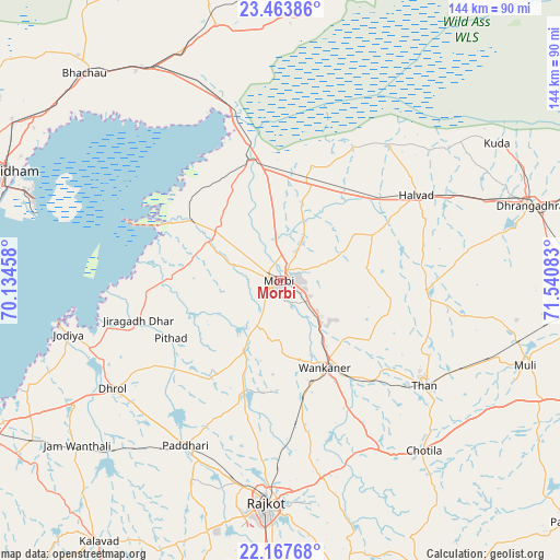
Morbi GPS coordinates[2]
22° 49' 2.316" North, 70° 50' 15.72" East
| Map corner | latitude | longitude |
|---|---|---|
| Upper-left | 23.46386°, | 70.13458° |
| Center: | 22.81731°, | 70.8377° |
| Lower-right: | 22.16768°, | 71.54083° |
| Map W x H: | 144.1×144.1 km | = 89.5×89.5mi |
| max Lat: | 34.9274° ⇑49.9% North |
| Morbi: | 22.81731° |
| min Lat: | ⇓50.1% South 8.09008° |
| min Long | Morbi | max Long |
| 68.82655° | 70.8377° | 96.81° |
| W 1.3%⇐ | ⇒98.7% E |
Elevation
Elevation of Morbi is 53 m = 174 ft, and this is 242.6 m = 796 ft below average elevation for this country.
| Max E: |
3681 m = 12077 ft | 78.5% |
| Avg. | 295.6 m = 970 ft | |
| Morbi | 53 m = 174 ft | |
Min E: |
1 m = 3 ft | 21.5% |
See also: Morbi elevation on elevation.city.
Geographical zone
Morbi is located in North Torrid zone (between Equator and Tropic of Cancer). Distance of this Northern Tropic circle is 68.9 km =42.8 mi to North.| Distance of | km | miles | from Morbi |
|---|---|---|---|
| North Pole | 7470 | 4641.6 | to North |
| Arctic Circle | 4864.1 | 3022.4 | to North |
| Tropic Cancer | 68.9 | 42.8 | to North |
| Equator | 2537 | 1576.4 | to South |


Nearby cities:
15 places around Morbi: (largest is in red/bold)
• Bhachāu
73.7 km =45.8 mi,  316°
316°
• Chotila
57.2 km =35.5 mi,  139°
139°
• Dhrol
51.3 km =31.9 mi,  237°
237°
• Dhrāngadhra
67.4 km =41.9 mi,  73°
73°
• Gāndhīdhām
77.9 km =48.4 mi,  292°
292°
• Halvad
41.4 km =25.7 mi,  57°
57°
• Jodiya Bandar
57.9 km =36 mi,  258°
258°
• Kāndla
68 km =42.3 mi, 290°
• Paddhari
48.8 km =30.3 mi,  209°
209°
• Rājkot
58.6 km =36.4 mi,  184°
184°
• Shāhpur
73.8 km =45.9 mi,  185°
185°
• Sāyla
72.6 km =45.1 mi,  114°
114°
• Tankāra
20.1 km =12.5 mi, 206°
• Thān
45.9 km =28.5 mi,  126°
126°
• Wānkāner
25.3 km =15.7 mi,  154°
154°
Sources, notices
• [Note1] Compared only with cities in India existing in our database
• [Src1] Map data: © OpenStreetMap contributors (CC-BY-SA)
• [Src2] Other city data from geonames.org with taken over terms of usage.
• [Src3] Geographical zone / Annual Mean Temperature by Robert A. Rohde @ Wikipedia
