Rājāpur geodata
Rājāpur (Maharashtra) is a populated place; located in India in Asia/Kolkata (GMT+5.5) time zone. With population of 10,718 people, there are 2866 cities with bigger population in this country. Compared to other cities in India, 75.9% of cities are located further ↑North; 92.4% of cities are located further →East and 73.8% of cities have higher elevation than Rājāpur. Note1


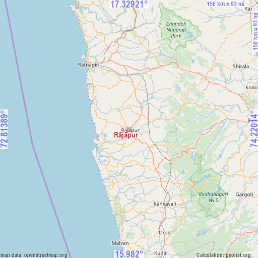
Rājāpur GPS coordinates[2]
16° 39' 24.444" North, 73° 31' 1.236" East
| Map corner | latitude | longitude |
|---|---|---|
| Upper-left | 17.32921°, | 72.81389° |
| Center: | 16.65679°, | 73.51701° |
| Lower-right: | 15.982°, | 74.22014° |
| Map W x H: | 149.8×149.8 km | = 93.1×93.1mi |
| max Lat: | 34.9274° ⇑75.9% North |
| Rājāpur: | 16.65679° |
| min Lat: | ⇓24.1% South 8.09008° |
| min Long | Rājāpur | max Long |
| 68.82655° | 73.51701° | 96.81° |
| W 7.6%⇐ | ⇒92.4% E |
Elevation
Elevation of Rājāpur is 74 m = 243 ft, and this is 221.6 m = 727 ft below average elevation for this country.
| Max E: |
3681 m = 12077 ft | 73.8% |
| Avg. | 295.6 m = 970 ft | |
| Rājāpur | 74 m = 243 ft | |
Min E: |
1 m = 3 ft | 26.2% |
See also: India elevation on elevation.city.
Geographical zone
Rājāpur is located in North Torrid zone (between Equator and Tropic of Cancer). Distance of this Northern Tropic circle is 753.9 km =468.5 mi to North.| Distance of | km | miles | from Rājāpur |
|---|---|---|---|
| North Pole | 8155 | 5067.3 | to North |
| Arctic Circle | 5549.1 | 3448 | to North |
| Tropic Cancer | 753.9 | 468.5 | to North |
| Equator | 1852.1 | 1150.8 | to South |


Nearby cities:
15 places around Rājāpur: (largest is in red/bold)
• Kankauli
48.2 km =30 mi,  154°
154°
• Kodoli
75.8 km =47.1 mi,  71°
71°
• Kolhāpur
76.2 km =47.3 mi,  86°
86°
• Koynanagar
86.8 km =53.9 mi,  17°
17°
• Kudāl
74.1 km =46 mi,  165°
165°
• Kāgal
85.5 km =53.1 mi,  95°
95°
• Lānja
23 km =14.3 mi,  8°
8°
• Malkāpur
53.2 km =33.1 mi,  56°
56°
• Murgūd
77.5 km =48.2 mi,  111°
111°
• Mākhjan
68.2 km =42.4 mi,  358°
358°
• Mālvan
66.6 km =41.4 mi,  184°
184°
• Panhāla
65.5 km =40.7 mi, 74°
• Pātan
89.7 km =55.7 mi,  27°
27°
• Ratnagiri
43.2 km =26.8 mi,  329°
329°
• Vengurla
89.3 km =55.5 mi, 172°
Sources, notices
• [Note1] Compared only with cities in India existing in our database
• [Src1] Map data: © OpenStreetMap contributors (CC-BY-SA)
• [Src2] Other city data from geonames.org with taken over terms of usage.
• [Src3] Geographical zone / Annual Mean Temperature by Robert A. Rohde @ Wikipedia
